Bohaiseamap2.png(᱕᱖᱙ x ᱔᱘᱗ pixels, file size: ᱑᱓᱖ KB, MIME type: image/png)

ᱱᱚᱣᱟ ᱨᱮᱫ ᱫᱚ ᱱᱚᱸᱰᱮ ᱠᱷᱚᱱ Wikimedia Commons ᱟᱨ ᱯᱟᱥᱮᱡ ᱮᱴᱟᱜ-ᱟ ᱯᱚᱨᱡᱮᱠᱴ ᱨᱮᱦᱚᱸ ᱵᱮᱵᱦᱟᱨᱚᱜ ᱠᱟᱱᱟ᱾ ᱱᱚᱣᱟ ᱨᱮᱭᱟ ᱯᱟᱥᱱᱟᱣ ᱠᱟᱛᱷᱟ ᱨᱮᱫ ᱯᱟᱥᱱᱟᱣ ᱥᱟᱦᱴᱟ ᱞᱟᱛᱟᱨᱨᱮ ᱮᱢ ᱮᱱᱟ᱾

Warning sign This file requires updating because: I suggest using the more normative 'Pyongyang' and 'Yellow River' or at least adding these forms in parentheses. In doing so, you could add a timestamp to the file.
Please notify the uploader with {{subst:update-note|1=File:Bohaiseamap2.png|2=I suggest using the more normative 'Pyongyang' and 'Yellow River' or at least adding these forms in parentheses.}} ~~~~

ᱢᱩᱬᱩᱛ ᱠᱟᱛᱷᱟ

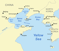
ᱵᱤᱵᱚᱨᱚᱱᱤ Map of the Bohai Sea and surrounding bays. For a more general map of the same area see Image:Bohai Sea map.png
ᱢᱟᱹᱦᱤᱛ
ᱯᱷᱮᱰᱟᱛ self-made, based on DCW data.
ᱚᱱᱚᱞᱤᱭᱟᱹ Kmusser
Other versions

Derivative works of this file:

This map image could be re-created using vector graphics as an SVG file. This has several advantages; see Commons:Media for cleanup for more information. If an SVG form of this image is available, please upload it and afterwards replace this template with {{vector version available|new image name}}.


It is recommended to name the SVG file “Bohaiseamap2.svg”—then the template Vector version available (or Vva) does not need the new image name parameter.

ᱞᱟᱭᱥᱮᱱᱥ ᱛᱮᱭᱟᱨ

I, the copyright holder of this work, hereby publish it under the following license:
w:en:Creative Commons
ᱟᱴᱨᱤᱵᱩᱥᱚᱱ ᱦᱟᱹᱴᱤᱧ ᱱᱚᱝᱠᱟ ᱜᱮ
This file is licensed under the Creative Commons Attribution-Share Alike 2.5 Generic license.
ᱟᱲᱟᱜ ᱜᱮᱭᱟᱢ:
  • ᱦᱟᱹᱴᱤᱧᱢᱮ – ᱱᱚᱠᱚᱞ ᱞᱟᱹᱜᱤᱫ, ᱦᱟᱹᱴᱤᱧ ᱟᱨ ᱵᱷᱮᱡᱟᱭᱢᱮ ᱠᱟᱹᱢᱤ
  • ᱢᱮᱥᱟᱣᱠᱟᱛᱢᱮ – ᱠᱟᱹᱢᱤ ᱟᱞᱜᱟᱭ ᱞᱟᱹᱜᱤᱫ
ᱞᱟᱛᱟᱨ ᱨᱮᱭᱟᱜ ᱨᱤᱛ ᱞᱮᱠᱟᱛᱮ:
  • ᱟᱴᱨᱤᱵᱩᱥᱚᱱ – ᱟᱢ ᱠᱟᱹᱢᱤ ᱥᱚᱫᱚᱨ ᱦᱩᱭᱟᱢᱟ ᱡᱚᱠᱷᱚᱱ ᱚᱱᱚᱞᱤᱭᱟᱹ ᱟᱨᱵᱟᱝ ᱞᱟᱭᱥᱮᱸᱥᱩᱭᱟᱹ ᱫᱟᱨᱟᱭᱛᱮ ᱠᱟᱛᱷᱟ ᱨᱟᱠᱟᱵ ᱠᱷᱟᱱ (ᱢᱮᱱᱠᱷᱟᱱ ᱟᱠᱚ ᱩᱫᱩᱜᱟᱜ ᱦᱚᱨ ᱛᱮᱫᱚ ᱵᱟᱝ ᱡᱟᱦᱟᱸ ᱟᱠᱚᱠᱚ ᱜᱚᱲᱚᱣᱟᱢ ᱟᱨᱵᱟᱝ ᱟᱢᱟᱜ ᱠᱟᱹᱢᱤ ᱨᱮᱱᱟᱜ ᱵᱮᱵᱷᱟᱨ)
  • ᱦᱟᱹᱴᱤᱧ ᱱᱚᱝᱠᱟ ᱜᱮ – ᱟᱢ ᱡᱩᱫᱤ ᱠᱟᱹᱢᱤ ᱵᱚᱫᱚᱞ, ᱛᱚᱨᱡᱚᱢᱟ, ᱵᱟᱝᱠᱷᱟᱱ ᱱᱚᱣᱟ ᱠᱟᱹᱢᱤ ᱪᱮᱛᱟᱱᱨᱮ ᱱᱟᱣᱟ ᱠᱟᱹᱢᱤ ᱥᱤᱨᱡᱟᱹᱣᱮᱢ ᱛᱮᱭᱟᱨ ᱠᱷᱟᱱ, ᱛᱚᱵᱮ ᱟᱢ ᱫᱚ ᱚᱱᱟ ᱠᱟᱹᱢᱤ ᱚᱱᱟ ᱢᱤᱫ ᱞᱟᱤᱥᱮᱱᱥ ᱥᱮ ᱚᱱᱟ ᱞᱮᱠᱟᱱᱟᱜ ᱞᱟᱤᱥᱮᱱᱥ ᱨᱮᱜᱮ ᱪᱟᱞ ᱦᱩᱭᱩᱜ ᱛᱟᱢᱟ᱾

Captions

Add a one-line explanation of what this file represents
Map of the Bohai Sea and surrounding bays

Items portrayed in this file

ᱞᱟ.ᱭᱟᱭ

Bohai Sea ᱟᱝᱜᱽᱨᱮᱡᱤ

creator ᱟᱝᱜᱽᱨᱮᱡᱤ

some value

author name string ᱟᱝᱜᱽᱨᱮᱡᱤ: Kmusser
Wikimedia username ᱟᱝᱜᱽᱨᱮᱡᱤ: Kmusser

copyright status ᱟᱝᱜᱽᱨᱮᱡᱤ

copyrighted ᱟᱝᱜᱽᱨᱮᱡᱤ

copyright license ᱟᱝᱜᱽᱨᱮᱡᱤ

inception ᱟᱝᱜᱽᱨᱮᱡᱤ

᱒᱗ ᱡᱩᱱ 2007

MIME type ᱟᱝᱜᱽᱨᱮᱡᱤ

image/png

checksum ᱟᱝᱜᱽᱨᱮᱡᱤ

e776fb894d1db142a63c8f0d600c8d6c18de759c

determination method ᱟᱝᱜᱽᱨᱮᱡᱤ: SHA-1 ᱟᱝᱜᱽᱨᱮᱡᱤ

data size ᱟᱝᱜᱽᱨᱮᱡᱤ

᱑᱓᱙,᱑᱐᱐ byte

height ᱟᱝᱜᱽᱨᱮᱡᱤ

᱔᱘᱗ pixel

width ᱟᱝᱜᱽᱨᱮᱡᱤ

᱕᱖᱙ pixel

ᱨᱮᱫ ᱨᱮᱭᱟᱜ ᱱᱟᱜᱟᱢ

ᱚᱠᱛᱚ ᱨᱮ ᱞᱤᱱ ᱢᱮ/ᱚᱠᱛᱚ ᱨᱮ ᱨᱮᱫ ᱧᱮᱞ ᱞᱟᱹᱜᱤᱛ ᱞᱤᱱ ᱢᱮ

ᱢᱟᱹᱦᱤᱛ/ᱚᱠᱛᱚᱴᱤᱯᱡᱚᱠᱷᱟᱵᱮᱵᱷᱟᱨᱤᱭᱟᱹᱠᱟᱛᱷᱟ
ᱱᱤᱛᱚᱜ᱑᱙:᱓᱓, ᱗ ᱡᱟᱱᱩᱣᱟᱨᱤ ᱒᱐᱒᱑᱑᱙:᱓᱓, ᱗ ᱡᱟᱱᱩᱣᱟᱨᱤ ᱒᱐᱒᱑ ᱞᱮᱠᱟᱛᱮ ᱛᱷᱚᱢᱵᱽᱱᱮᱞ ᱵᱷᱚᱨᱥᱚᱱ᱕᱖᱙ × ᱔᱘᱗ (᱑᱓᱖ KB)Ras67black frame cropped and alpha channel removed
᱑᱔:᱕᱙, ᱒᱗ ᱡᱩᱱ ᱒᱐᱐᱗᱑᱔:᱕᱙, ᱒᱗ ᱡᱩᱱ ᱒᱐᱐᱗ ᱞᱮᱠᱟᱛᱮ ᱛᱷᱚᱢᱵᱽᱱᱮᱞ ᱵᱷᱚᱨᱥᱚᱱ᱕᱘᱓ × ᱕᱐᱐ (᱑᱗᱙ KB)Kmusseradded strait
᱑᱔:᱕᱐, ᱒᱗ ᱡᱩᱱ ᱒᱐᱐᱗᱑᱔:᱕᱐, ᱒᱗ ᱡᱩᱱ ᱒᱐᱐᱗ ᱞᱮᱠᱟᱛᱮ ᱛᱷᱚᱢᱵᱽᱱᱮᱞ ᱵᱷᱚᱨᱥᱚᱱ᱕᱐᱐ × ᱔᱒᱙ (᱑᱔᱑ KB)Kmusser{{Information |Description=Map of the Bohai Sea and surrounding bays. For a more general map of the same area see Image:Bohai Sea map.png |Source=self-made, based on DCW data. |Date=June 27, 2007

ᱞᱟᱛᱟᱨ ᱨᱮᱭᱟᱜ ᱥᱟᱦᱴᱟ ᱡᱚᱱᱚᱲᱠᱚ ᱱᱤᱭᱟᱹ ᱨᱮᱫ ᱨᱮ:

ᱡᱮᱜᱮᱛ ᱡᱟᱠᱟᱛ ᱨᱮᱫ ᱵᱮᱵᱷᱟᱨᱟᱜ

ᱱᱚᱶᱟ ᱨᱮᱫᱠᱚ ᱵᱮᱵᱷᱟᱨᱟᱠᱟᱫ ᱣᱤᱠᱤᱠᱚ :

ᱱᱚᱶᱟ ᱨᱮᱫ ᱨᱮᱱᱟᱜ ᱵᱟᱹᱲᱛᱤ ᱡᱮᱜᱮᱛ ᱵᱮᱵᱷᱟᱨ ᱧᱮᱞ ᱢᱮ ᱾

ᱢᱮᱴᱟ ᱥᱟᱹᱠᱷᱭᱟᱹᱛ

"https://sat.wikipedia.org/wiki/ᱨᱮᱫ:Bohaiseamap2.png" ᱠᱷᱚᱱ ᱧᱟᱢ ᱟᱹᱜᱩᱭ