ᱨᱮᱫ:Borneo Topography.png

ᱧᱮᱞᱡᱚᱝ ᱨᱮᱱᱟᱜ ᱟᱠᱟᱨ:᱕᱖᱗ × ᱖᱐᱐ ᱯᱤᱠᱥᱮᱞ ᱮᱴᱟᱜ ᱨᱤᱡᱚᱞᱩᱥᱚᱱᱥ: ᱒᱒᱗ × ᱒᱔᱐ ᱯᱤᱠᱥᱮᱞ | ᱔᱕᱔ × ᱔᱘᱐ ᱯᱤᱠᱥᱮᱞ | ᱗᱒᱖ × ᱗᱖᱘ ᱯᱤᱠᱥᱮᱞ | ᱙᱖᱘ × ᱑,᱐᱒᱔ ᱯᱤᱠᱥᱮᱞ | ᱑,᱗᱒᱕ × ᱑,᱘᱒᱔ ᱯᱤᱠᱥᱮᱞ
ᱟᱥᱚᱞ ᱨᱮᱫ (᱑,᱗᱒᱕ x ᱑,᱘᱒᱔ pixels, file size: ᱒.᱕᱒ MB, MIME type: image/png)
ᱢᱩᱬᱩᱛ ᱠᱟᱛᱷᱟ
| ᱵᱤᱵᱚᱨᱚᱱᱤ |
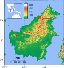
English: Relief (hypsometric) map of Borneo. Red lines represent national borders between Indonesia (south), Malaysia (north), and Brunei (top north). Created with GMT from publicly released GLOBE data[1]. For locator version, see File:Borneo Locator Topography.png.
Français : Carte du relief de l'île de Borneo. Les lignes rouges représentent les frontières séparant les états se partageant l'île de Bornéo : L'Indonésie (au sud), la Malaisie (au nord de l'Indonésie) et l'état de Bruneï (au nord de la Malaisie). Image produite à l'aide de la suite logicielle GMT à partir des données publiques GLOBE. Une version locator est disponible. |
| ᱢᱟᱹᱦᱤᱛ | |
| ᱯᱷᱮᱰᱟᱛ | ᱤᱧᱟᱜ ᱠᱟᱹᱢᱤ |
| ᱚᱱᱚᱞᱤᱭᱟᱹ | Sadalmelik |

|
This image has been assessed under the valued image criteria and is considered the most valued image on Commons within the scope: Hypsometric map of Borneo. You can see its nomination here. |
ᱞᱟᱭᱥᱮᱱᱥ ᱛᱮᱭᱟᱨ
| I, the copyright holder of this work, release this work into the public domain. This applies worldwide. In some countries this may not be legally possible; if so: I grant anyone the right to use this work for any purpose, without any conditions, unless such conditions are required by law. |
ᱨᱮᱫ ᱨᱮᱭᱟᱜ ᱱᱟᱜᱟᱢ
ᱚᱠᱛᱚ ᱨᱮ ᱞᱤᱱ ᱢᱮ/ᱚᱠᱛᱚ ᱨᱮ ᱨᱮᱫ ᱧᱮᱞ ᱞᱟᱹᱜᱤᱛ ᱞᱤᱱ ᱢᱮ
| ᱢᱟᱹᱦᱤᱛ/ᱚᱠᱛᱚ | ᱴᱤᱯ | ᱡᱚᱠᱷᱟ | ᱵᱮᱵᱷᱟᱨᱤᱭᱟᱹ | ᱠᱟᱛᱷᱟ | |
|---|---|---|---|---|---|
| ᱱᱤᱛᱚᱜ | ᱑᱙:᱑᱗, ᱑ ᱥᱮᱯᱴᱮᱢᱵᱚᱨ ᱒᱐᱐᱗ | | ᱑,᱗᱒᱕ × ᱑,᱘᱒᱔ (᱒.᱕᱒ MB) | Sadalmelik | Better data, better colours |
| ᱒᱐:᱕᱔, ᱓ ᱡᱩᱱ ᱒᱐᱐᱗ |  | ᱒,᱐᱘᱓ × ᱒,᱑᱕᱘ (᱑.᱖᱗ MB) | Sadalmelik | {{Information |Description=Topographical map of Borneo. Created with GMT from publicly released GLOBE data[http://www.ngdc.noaa.gov/mgg/topo/globe.html]. |Source=self-made |Date=June 3, 2007 |Author= User:Sadalmelik }} Category:Maps of Malaysia |
ᱯᱷᱟᱭᱤᱞ ᱵᱮᱣᱦᱟᱨ
ᱞᱟᱛᱟᱨ ᱨᱮᱭᱟᱜ ᱥᱟᱦᱴᱟ ᱡᱚᱱᱚᱲᱠᱚ ᱱᱤᱭᱟᱹ ᱨᱮᱫ ᱨᱮ:
ᱡᱮᱜᱮᱛ ᱡᱟᱠᱟᱛ ᱨᱮᱫ ᱵᱮᱵᱷᱟᱨᱟᱜ
ᱱᱚᱶᱟ ᱨᱮᱫᱠᱚ ᱵᱮᱵᱷᱟᱨᱟᱠᱟᱫ ᱣᱤᱠᱤᱠᱚ :
- af.wikipedia.org ᱨᱮ ᱵᱮᱣᱦᱟᱨ
- ar.wikipedia.org ᱨᱮ ᱵᱮᱣᱦᱟᱨ
- az.wikipedia.org ᱨᱮ ᱵᱮᱣᱦᱟᱨ
- ban.wikipedia.org ᱨᱮ ᱵᱮᱣᱦᱟᱨ
- be-tarask.wikipedia.org ᱨᱮ ᱵᱮᱣᱦᱟᱨ
- be.wikipedia.org ᱨᱮ ᱵᱮᱣᱦᱟᱨ
- bg.wikipedia.org ᱨᱮ ᱵᱮᱣᱦᱟᱨ
- bn.wikipedia.org ᱨᱮ ᱵᱮᱣᱦᱟᱨ
- ca.wikipedia.org ᱨᱮ ᱵᱮᱣᱦᱟᱨ
- ceb.wikipedia.org ᱨᱮ ᱵᱮᱣᱦᱟᱨ
- de.wikipedia.org ᱨᱮ ᱵᱮᱣᱦᱟᱨ
- de.wikivoyage.org ᱨᱮ ᱵᱮᱣᱦᱟᱨ
- de.wiktionary.org ᱨᱮ ᱵᱮᱣᱦᱟᱨ
- el.wikipedia.org ᱨᱮ ᱵᱮᱣᱦᱟᱨ
- el.wiktionary.org ᱨᱮ ᱵᱮᱣᱦᱟᱨ
- en.wikipedia.org ᱨᱮ ᱵᱮᱣᱦᱟᱨ
- Borneo
- East Malaysia
- Talk:Borneo
- List of endemic birds of Borneo
- Outline of Malaysia
- User:Chickstarr404/Gather lists/13386 – "A Travelers Alphabet" by Stephen Runciman
- Wikipedia:Today's featured list/June 2021
- Wikipedia:Today's featured list/June 11, 2021
- Wikipedia:Main Page history/2021 June 11
- Wikipedia:Main Page history/2021 June 11b
- Phalaenopsis kapuasensis
- Phalaenopsis luteola
- Phalaenopsis modesta
- Phalaenopsis pantherina
- Phalaenopsis × singuliflora
- User:AryKun/Misc
- Naval Base Borneo
- User:Asang Lawai
- Template:User Dayak
- en.wikibooks.org ᱨᱮ ᱵᱮᱣᱦᱟᱨ
- en.wikinews.org ᱨᱮ ᱵᱮᱣᱦᱟᱨ
- eo.wikipedia.org ᱨᱮ ᱵᱮᱣᱦᱟᱨ
- es.wikipedia.org ᱨᱮ ᱵᱮᱣᱦᱟᱨ
- et.wikipedia.org ᱨᱮ ᱵᱮᱣᱦᱟᱨ
- eu.wikipedia.org ᱨᱮ ᱵᱮᱣᱦᱟᱨ
- fa.wikipedia.org ᱨᱮ ᱵᱮᱣᱦᱟᱨ
- fi.wikipedia.org ᱨᱮ ᱵᱮᱣᱦᱟᱨ
- fo.wikipedia.org ᱨᱮ ᱵᱮᱣᱦᱟᱨ
- frr.wikipedia.org ᱨᱮ ᱵᱮᱣᱦᱟᱨ
- fr.wikipedia.org ᱨᱮ ᱵᱮᱣᱦᱟᱨ
ᱱᱚᱶᱟ ᱨᱮᱫ ᱨᱮᱱᱟᱜ ᱵᱟᱹᱲᱛᱤ ᱡᱮᱜᱮᱛ ᱵᱮᱵᱷᱟᱨ ᱧᱮᱞ ᱢᱮ ᱾