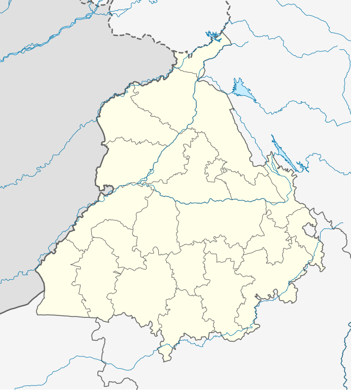
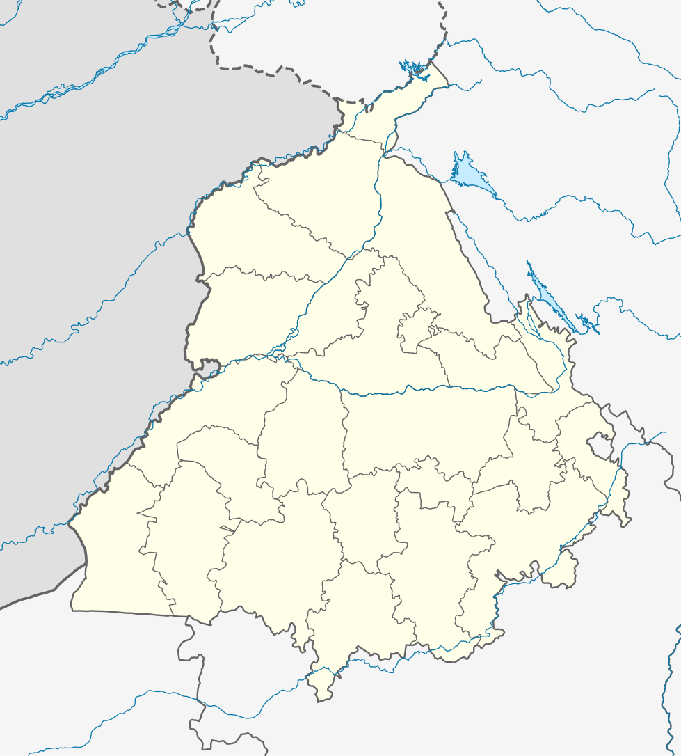
ᱨᱮᱫ:India Punjab location map.svg

ᱟᱥᱚᱞ ᱨᱮᱫ (SVG ᱨᱮᱫ, ᱱᱚᱨᱢᱟᱞᱛᱮ ᱙᱗᱙ x ᱑,᱐᱘᱖ pixels, ᱨᱮᱫ ᱡᱟᱜᱟ: ᱓᱑᱑ KB)
ᱢᱩᱬᱩᱛ ᱠᱟᱛᱷᱟ
| ᱵᱤᱵᱚᱨᱚᱱᱤ |
Quadratische Plattkarte, N-S-Streckung 117 %. Geographische Begrenzung der Karte:
Equirectangular projection, N/S stretching 117 %. Geographic limits of the map:
|
|
| ᱢᱟᱹᱦᱤᱛ | ||
| ᱯᱷᱮᱰᱟᱛ |
ᱤᱧᱟᱜ ᱠᱟᱹᱢᱤ, using
|
|
| ᱚᱱᱚᱞᱤᱭᱟᱹ | NordNordWest | |
| ᱟᱹᱭᱫᱟᱹᱨᱤ (ᱱᱚᱣᱟ ᱨᱮᱫ ᱫᱚᱲᱦᱟᱛᱮ ᱵᱮᱵᱷᱟᱨ) |
This file is licensed under the Creative Commons Attribution-Share Alike 3.0 Germany license.
 This file is licensed under the Creative Commons Attribution-Share Alike 3.0 Germany license.
|


|
This map has been made or improved in the German Kartenwerkstatt (Map Lab). You can propose maps to improve as well.
|
ᱨᱮᱫ ᱨᱮᱭᱟᱜ ᱱᱟᱜᱟᱢ
ᱚᱠᱛᱚ ᱨᱮ ᱞᱤᱱ ᱢᱮ/ᱚᱠᱛᱚ ᱨᱮ ᱨᱮᱫ ᱧᱮᱞ ᱞᱟᱹᱜᱤᱛ ᱞᱤᱱ ᱢᱮ
| ᱢᱟᱹᱦᱤᱛ/ᱚᱠᱛᱚ | ᱴᱤᱯ | ᱡᱚᱠᱷᱟ | ᱵᱮᱵᱷᱟᱨᱤᱭᱟᱹ | ᱠᱟᱛᱷᱟ | |
|---|---|---|---|---|---|
| ᱱᱤᱛᱚᱜ | ᱐᱔:᱑᱙, ᱑᱙ ᱚᱜᱚᱥᱴ ᱒᱐᱒᱒ | | ᱙᱗᱙ × ᱑,᱐᱘᱖ (᱓᱑᱑ KB) | C1MM | Fixed Ludhiana district |
| ᱐᱔:᱐᱓, ᱑᱙ ᱚᱜᱚᱥᱴ ᱒᱐᱒᱒ |  | ᱙᱗᱙ × ᱑,᱐᱘᱖ (᱓᱑᱒ KB) | C1MM | Resized to original size | |
| ᱐᱓:᱕᱗, ᱑᱙ ᱚᱜᱚᱥᱴ ᱒᱐᱒᱒ |  | ᱙᱕᱑ × ᱘᱙᱘ (᱓᱒᱔ KB) | C1MM | Added Malerkotla district, fixed rivers and disputed boundaries for Jammu and Kashmir | |
| ᱐᱓:᱒᱓, ᱑᱕ ᱡᱟᱱᱩᱣᱟᱨᱤ ᱒᱐᱒᱑ |  | ᱑,᱐᱔᱙ × ᱑,᱑᱖᱑ (᱑᱑᱔ KB) | C1MM | Added Tan Taran district | |
| ᱑᱘:᱑᱑, ᱒᱔ ᱚᱠᱴᱚᱵᱚᱨ ᱒᱐᱒᱐ |  | ᱑,᱐᱔᱙ × ᱑,᱑᱖᱑ (᱑᱑᱐ KB) | C1MM | Updated districts | |
| ᱑᱗:᱔᱑, ᱔ ᱢᱮ ᱒᱐᱑᱒ |  | ᱑,᱐᱔᱙ × ᱑,᱑᱖᱑ (᱑᱐᱗ KB) | NordNordWest | upd | |
| ᱒᱐:᱒᱔, ᱑᱙ ᱢᱮ ᱒᱐᱑᱐ |  | ᱑,᱐᱔᱙ × ᱑,᱑᱖᱑ (᱑᱐᱔ KB) | NordNordWest | c | |
| ᱒᱐:᱑᱑, ᱑᱙ ᱢᱮ ᱒᱐᱑᱐ |  | ᱑,᱐᱔᱙ × ᱑,᱑᱖᱑ (᱑᱐᱕ KB) | NordNordWest | =={{int:filedesc}}== {{Information |Description= {{de|Positionskarte von Punjab, Indien}} Quadratische Plattkarte, N-S-Streckung 117 %. Geographische Begrenzung der Karte: * N: 32.8° N * S: 29.3° N * W: 73.5° O * |
ᱯᱷᱟᱭᱤᱞ ᱵᱮᱣᱦᱟᱨ
ᱞᱟᱛᱟᱨ ᱨᱮᱭᱟᱜ 29 ᱥᱟᱦᱴᱟᱠᱚ ᱡᱚᱱᱚᱲ ᱱᱤᱭᱟᱹ ᱨᱮᱫ ᱨᱮ:
- ᱜᱩᱨᱫᱟᱥᱯᱩᱨ
- ᱞᱩᱫᱷᱤᱭᱟᱱᱟ
- ᱞᱩᱫᱷᱤᱭᱟᱱᱟ ᱡᱚᱸᱠᱥᱚᱱ ᱨᱮᱞᱣᱮ ᱥᱴᱮᱥᱚᱱ
- ᱟᱢᱨᱤᱛᱥᱚᱨ
- ᱟᱵᱳᱦᱟᱨ ᱡᱚᱸᱠᱥᱚᱱ ᱨᱮᱞᱣᱮ ᱥᱴᱮᱥᱚᱱ
- ᱠᱟᱯᱩᱨᱛᱷᱟᱞᱟ ᱨᱮᱞᱣᱮ ᱥᱴᱮᱥᱚᱱ
- ᱡᱚᱞᱚᱱᱫᱷᱚᱨ
- ᱡᱚᱞᱚᱱᱫᱷᱚᱨ ᱥᱚᱦᱚᱨ ᱡᱚᱸᱠᱥᱚᱱ ᱨᱮᱞᱣᱮ ᱥᱴᱮᱥᱚᱱ
- ᱢᱚᱜᱟ, ᱯᱚᱧᱡᱟᱵᱽ
- ᱢᱚᱦᱟᱞᱤ
- ᱢᱟᱱᱥᱟ ᱨᱮᱞᱣᱮ ᱥᱴᱮᱥᱚᱱ
- ᱥᱚᱝᱨᱩᱨ ᱨᱮᱞᱣᱮ ᱥᱴᱮᱥᱚᱱ
- ᱦᱚᱥᱤᱭᱟᱨᱯᱩᱨ
- ᱦᱟᱢᱤᱨᱟ ᱨᱮᱞᱣᱮ ᱥᱴᱮᱥᱚᱱ
- ᱨᱟᱡᱽᱯᱩᱨᱟ ᱡᱚᱸᱠᱥᱚᱱ ᱨᱮᱞᱣᱮ ᱥᱴᱮᱥᱚᱱ
- ᱨᱩᱯᱱᱚᱜᱚᱨ
- ᱪᱤᱦᱮᱨᱩ ᱨᱮᱞᱣᱮ ᱥᱴᱮᱥᱚᱱ
- ᱫᱷᱩᱨᱤ ᱡᱚᱸᱠᱥᱚᱱ ᱨᱮᱞᱣᱮ ᱥᱴᱮᱥᱚᱱ
- ᱯᱟᱴᱤᱭᱟᱞᱟ
- ᱯᱟᱴᱷᱟᱱᱠᱳᱴ
- ᱯᱷᱚᱨᱤᱫᱽᱠᱳᱴ ᱨᱮᱞᱣᱮ ᱥᱴᱮᱥᱚᱱ
- ᱯᱷᱟᱜᱽᱣᱟᱲᱟ ᱡᱚᱸᱠᱥᱚᱱ ᱨᱮᱞᱣᱮ ᱥᱴᱮᱥᱚᱱ
- ᱯᱷᱟᱡᱤᱞᱠᱟ
- ᱯᱷᱤᱨᱚᱡᱽᱯᱩᱨ
- ᱰᱷᱤᱞᱶᱟ ᱨᱮᱞᱣᱮ ᱥᱴᱮᱥᱚᱱ
- ᱱᱟᱶᱟᱥᱚᱦᱚᱨ
- ᱵᱚᱨᱱᱟᱞᱟ
- ᱵᱚᱨᱱᱟᱞᱟ ᱨᱮᱞᱣᱮ ᱥᱴᱮᱥᱚᱱ
- ᱵᱚᱴᱷᱤᱱᱰᱟ
ᱡᱮᱜᱮᱛ ᱡᱟᱠᱟᱛ ᱨᱮᱫ ᱵᱮᱵᱷᱟᱨᱟᱜ
ᱱᱚᱶᱟ ᱨᱮᱫᱠᱚ ᱵᱮᱵᱷᱟᱨᱟᱠᱟᱫ ᱣᱤᱠᱤᱠᱚ :
- ar.wikipedia.org ᱨᱮ ᱵᱮᱣᱦᱟᱨ
- as.wikipedia.org ᱨᱮ ᱵᱮᱣᱦᱟᱨ
- azb.wikipedia.org ᱨᱮ ᱵᱮᱣᱦᱟᱨ
- علیپور-۲
- علیپور-۱
- علی چاک
- علادینپور
- علیخل، جالاندر
- فول ماکاوری
- فیالی (هیندوستان)
- فاروالا, جالاندهار
- فارالا
- فانقوتا
- فامبرا
- فالپوتا
- ساروپوال
- ساروپوال, سولطانپور لودهی
- سارتی, قورداسپور
- سارنانا
- سارینه, لودهیانا
- سارینه, جالاندهار
- سارهالی
- سارهالی, جالاندهار
- سارهال کازیان
- سارهال موندی
- سارقوندی
- سارانقوال
- سارانقرا
- سارای خاس
- سارای خام
- سارای جاتان
- ساپرور
- مدا, پنجاب
- مازاری, اسبیاس ناقار
- مازارا ناو آباد
- مازارا خورد
- مازارا کالان
- سانورا
- ماوای, جالاندهار
- ماولی, فاقوارا
- ماوجیا
- ماو, پنجاب
- ماتوی, پنجاب
- سانقرای
- سانقرا, سولطانپور لودهی
- سانقووال
- سانقوجلا
- سانقول
- سانقرا (کند)
ᱱᱚᱶᱟ ᱨᱮᱫ ᱨᱮᱱᱟᱜ ᱵᱟᱹᱲᱛᱤ ᱡᱮᱜᱮᱛ ᱵᱮᱵᱷᱟᱨ ᱧᱮᱞ ᱢᱮ ᱾