ᱨᱮᱫ:LanguageMap-Kikongo-Kituba.png

ᱧᱮᱞᱡᱚᱝ ᱨᱮᱱᱟᱜ ᱟᱠᱟᱨ:᱘᱐᱐ × ᱕᱒᱙ ᱯᱤᱠᱥᱮᱞ ᱮᱴᱟᱜ ᱨᱤᱡᱚᱞᱩᱥᱚᱱᱥ: ᱓᱒᱐ × ᱒᱑᱒ ᱯᱤᱠᱥᱮᱞ | ᱖᱔᱐ × ᱔᱒᱓ ᱯᱤᱠᱥᱮᱞ | ᱑,᱐᱒᱔ × ᱖᱗᱗ ᱯᱤᱠᱥᱮᱞ | ᱑,᱔᱒᱐ × ᱙᱓᱙ ᱯᱤᱠᱥᱮᱞ
ᱟᱥᱚᱞ ᱨᱮᱫ (᱑,᱔᱒᱐ x ᱙᱓᱙ pixels, file size: ᱘᱙ KB, MIME type: image/png)
ᱢᱩᱬᱩᱛ ᱠᱟᱛᱷᱟ
| ᱵᱤᱵᱚᱨᱚᱱᱤ |
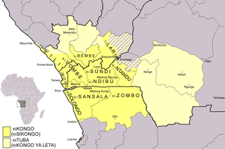
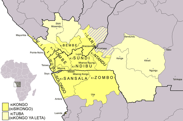
Dialect map of Kikongo. Dark yellow areas are inhabited mainly by first language speakers of the various dialects/languages of Kikongo. Names of some dialects/languages are written on the map. Pale yellow areas are inhabited by first and second language speakers of Kituba (a.k.a. Kikongo ya Leta), which is the lingua franca in the area. Kituba is understood by most speakers of Kikongo. Map drawn by Risto Kupsala. Details are based on the language maps of Ethnologue and several other sources. |
| ᱢᱟᱹᱦᱤᱛ | ᱒ ᱮᱯᱨᱤᱞ ᱒᱐᱐᱖ (original upload date) |
| ᱯᱷᱮᱰᱟᱛ | No machine-readable source provided. Own work assumed (based on copyright claims). |
| ᱚᱱᱚᱞᱤᱭᱟᱹ | No machine-readable author provided. Rasulo~commonswiki assumed (based on copyright claims). |
ᱞᱟᱭᱥᱮᱱᱥ ᱛᱮᱭᱟᱨ
| I, the copyright holder of this work, release this work into the public domain. This applies worldwide. In some countries this may not be legally possible; if so: I grant anyone the right to use this work for any purpose, without any conditions, unless such conditions are required by law. |
ᱨᱮᱫ ᱨᱮᱭᱟᱜ ᱱᱟᱜᱟᱢ
ᱚᱠᱛᱚ ᱨᱮ ᱞᱤᱱ ᱢᱮ/ᱚᱠᱛᱚ ᱨᱮ ᱨᱮᱫ ᱧᱮᱞ ᱞᱟᱹᱜᱤᱛ ᱞᱤᱱ ᱢᱮ
| ᱢᱟᱹᱦᱤᱛ/ᱚᱠᱛᱚ | ᱴᱤᱯ | ᱡᱚᱠᱷᱟ | ᱵᱮᱵᱷᱟᱨᱤᱭᱟᱹ | ᱠᱟᱛᱷᱟ | |
|---|---|---|---|---|---|
| ᱱᱤᱛᱚᱜ | ᱐᱐:᱓᱗, ᱒᱕ ᱯᱷᱮᱵᱽᱨᱩᱣᱟᱨᱤ ᱒᱐᱒᱑ | | ᱑,᱔᱒᱐ × ᱙᱓᱙ (᱘᱙ KB) | Somebody040404 | Reverted to version as of 10:10, 29 March 2018 (UTC) |
| ᱐᱐:᱒᱖, ᱒᱕ ᱯᱷᱮᱵᱽᱨᱩᱣᱟᱨᱤ ᱒᱐᱒᱑ |  | ᱑,᱔᱒᱐ × ᱙᱓᱙ (᱘᱒ KB) | Somebody040404 | ||
| ᱑᱐:᱑᱐, ᱒᱙ ᱢᱟᱨᱪ ᱒᱐᱑᱘ |  | ᱑,᱔᱒᱐ × ᱙᱓᱙ (᱘᱙ KB) | Maphobbyist | South Sudan border | |
| ᱒᱑:᱒᱔, ᱒᱐ ᱰᱤᱥᱮᱢᱵᱚᱨ ᱒᱐᱐᱗ |  | ᱑,᱔᱒᱐ × ᱙᱓᱙ (᱖᱐ KB) | Rasulo~commonswiki | Dialect map of Kikongo. Dark yellow areas are inhabited mainly by native speakers of the various dialects/languages of Ki(si)kongo. Names of some dialects/languages are written on the map. Pale yellow areas are inhabited by first and second language speak | |
| ᱑᱒:᱑᱒, ᱒᱒ ᱡᱩᱞᱟᱭ ᱒᱐᱐᱖ |  | ᱗᱑᱘ × ᱕᱑᱘ (᱒᱖ KB) | Rasulo~commonswiki | ||
| ᱐᱙:᱔᱙, ᱒ ᱮᱯᱨᱤᱞ ᱒᱐᱐᱖ |  | ᱕᱗᱑ × ᱔᱗᱑ (᱒᱐ KB) | Rasulo~commonswiki | Dialect map of Kikongo Dark green areas are inhabited mainly by first language speakers of the various dialects/languages of Kikongo. Names of some dialects/languages are written on the map. Light green areas are inhabited by first and second language spe |
ᱯᱷᱟᱭᱤᱞ ᱵᱮᱣᱦᱟᱨ
ᱞᱟᱛᱟᱨ ᱨᱮᱭᱟᱜ ᱥᱟᱦᱴᱟ ᱡᱚᱱᱚᱲᱠᱚ ᱱᱤᱭᱟᱹ ᱨᱮᱫ ᱨᱮ:
ᱡᱮᱜᱮᱛ ᱡᱟᱠᱟᱛ ᱨᱮᱫ ᱵᱮᱵᱷᱟᱨᱟᱜ
ᱱᱚᱶᱟ ᱨᱮᱫᱠᱚ ᱵᱮᱵᱷᱟᱨᱟᱠᱟᱫ ᱣᱤᱠᱤᱠᱚ :
- af.wikipedia.org ᱨᱮ ᱵᱮᱣᱦᱟᱨ
- ar.wikipedia.org ᱨᱮ ᱵᱮᱣᱦᱟᱨ
- ast.wikipedia.org ᱨᱮ ᱵᱮᱣᱦᱟᱨ
- az.wiktionary.org ᱨᱮ ᱵᱮᱣᱦᱟᱨ
- bn.wikipedia.org ᱨᱮ ᱵᱮᱣᱦᱟᱨ
- ca.wikipedia.org ᱨᱮ ᱵᱮᱣᱦᱟᱨ
- cs.wikipedia.org ᱨᱮ ᱵᱮᱣᱦᱟᱨ
- da.wikipedia.org ᱨᱮ ᱵᱮᱣᱦᱟᱨ
- de.wikipedia.org ᱨᱮ ᱵᱮᱣᱦᱟᱨ
- en.wikipedia.org ᱨᱮ ᱵᱮᱣᱦᱟᱨ
- eo.wikipedia.org ᱨᱮ ᱵᱮᱣᱦᱟᱨ
- es.wikipedia.org ᱨᱮ ᱵᱮᱣᱦᱟᱨ
- eu.wikipedia.org ᱨᱮ ᱵᱮᱣᱦᱟᱨ
- fi.wikipedia.org ᱨᱮ ᱵᱮᱣᱦᱟᱨ
- frr.wikipedia.org ᱨᱮ ᱵᱮᱣᱦᱟᱨ
- fr.wikipedia.org ᱨᱮ ᱵᱮᱣᱦᱟᱨ
ᱱᱚᱶᱟ ᱨᱮᱫ ᱨᱮᱱᱟᱜ ᱵᱟᱹᱲᱛᱤ ᱡᱮᱜᱮᱛ ᱵᱮᱵᱷᱟᱨ ᱧᱮᱞ ᱢᱮ ᱾