ᱨᱮᱫ:LocationBrunei.png
ᱥᱮᱬᱟ ᱨᱮᱡᱩᱞᱮᱥᱚᱱ ᱵᱟᱱᱩᱜ-ᱟ᱾
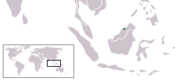
LocationBrunei.png (᱒᱕᱐ x ᱑᱑᱕ pixels, file size: ᱖ KB, MIME type: image/png)

|
This locator map image could be re-created using vector graphics as an SVG file. This has several advantages; see Commons:Media for cleanup for more information. If an SVG form of this image is available, please upload it and afterwards replace this template with
{{vector version available|new image name}}.
It is recommended to name the SVG file “LocationBrunei.svg”—then the template Vector version available (or Vva) does not need the new image name parameter. |
Location map for Brunei.
Originally created for English Wikipedia by Vardion.
| |
This work has been released into the public domain by its author, Vardion, at the ᱟᱝᱜᱽᱨᱮᱡᱤ ᱣᱤᱠᱤᱯᱤᱰᱤᱭᱟ project. This applies worldwide. In case this is not legally possible: |
ᱨᱮᱫ ᱨᱮᱭᱟᱜ ᱱᱟᱜᱟᱢ
ᱚᱠᱛᱚ ᱨᱮ ᱞᱤᱱ ᱢᱮ/ᱚᱠᱛᱚ ᱨᱮ ᱨᱮᱫ ᱧᱮᱞ ᱞᱟᱹᱜᱤᱛ ᱞᱤᱱ ᱢᱮ
| ᱢᱟᱹᱦᱤᱛ/ᱚᱠᱛᱚ | ᱴᱤᱯ | ᱡᱚᱠᱷᱟ | ᱵᱮᱵᱷᱟᱨᱤᱭᱟᱹ | ᱠᱟᱛᱷᱟ | |
|---|---|---|---|---|---|
| ᱱᱤᱛᱚᱜ | ᱐᱔:᱕᱔, ᱑᱔ ᱰᱤᱥᱮᱢᱵᱚᱨ ᱒᱐᱐᱔ | | ᱒᱕᱐ × ᱑᱑᱕ (᱖ KB) | EugeneZelenko | Location map for the Brunei.<br/>Originally created for English Wikipedia by Vardion.<br/>{{PD}}<br/>Category:Country locator maps |
ᱯᱷᱟᱭᱤᱞ ᱵᱮᱣᱦᱟᱨ
ᱞᱟᱛᱟᱨ ᱨᱮᱭᱟᱜ ᱥᱟᱦᱴᱟ ᱡᱚᱱᱚᱲᱠᱚ ᱱᱤᱭᱟᱹ ᱨᱮᱫ ᱨᱮ:
ᱡᱮᱜᱮᱛ ᱡᱟᱠᱟᱛ ᱨᱮᱫ ᱵᱮᱵᱷᱟᱨᱟᱜ
ᱱᱚᱶᱟ ᱨᱮᱫᱠᱚ ᱵᱮᱵᱷᱟᱨᱟᱠᱟᱫ ᱣᱤᱠᱤᱠᱚ :
- als.wikipedia.org ᱨᱮ ᱵᱮᱣᱦᱟᱨ
- ar.wikipedia.org ᱨᱮ ᱵᱮᱣᱦᱟᱨ
- as.wikipedia.org ᱨᱮ ᱵᱮᱣᱦᱟᱨ
- az.wikipedia.org ᱨᱮ ᱵᱮᱣᱦᱟᱨ
- be-tarask.wikipedia.org ᱨᱮ ᱵᱮᱣᱦᱟᱨ
- bg.wikipedia.org ᱨᱮ ᱵᱮᱣᱦᱟᱨ
- bg.wiktionary.org ᱨᱮ ᱵᱮᱣᱦᱟᱨ
- bn.wikipedia.org ᱨᱮ ᱵᱮᱣᱦᱟᱨ
- bpy.wikipedia.org ᱨᱮ ᱵᱮᱣᱦᱟᱨ
- br.wikipedia.org ᱨᱮ ᱵᱮᱣᱦᱟᱨ
- bs.wikipedia.org ᱨᱮ ᱵᱮᱣᱦᱟᱨ
- ca.wikipedia.org ᱨᱮ ᱵᱮᱣᱦᱟᱨ
- crh.wikipedia.org ᱨᱮ ᱵᱮᱣᱦᱟᱨ
- cs.wikipedia.org ᱨᱮ ᱵᱮᱣᱦᱟᱨ
- cv.wikipedia.org ᱨᱮ ᱵᱮᱣᱦᱟᱨ
- da.wikipedia.org ᱨᱮ ᱵᱮᱣᱦᱟᱨ
- de.wiktionary.org ᱨᱮ ᱵᱮᱣᱦᱟᱨ
- en.wikipedia.org ᱨᱮ ᱵᱮᱣᱦᱟᱨ
- en.wikinews.org ᱨᱮ ᱵᱮᱣᱦᱟᱨ
- en.wikivoyage.org ᱨᱮ ᱵᱮᱣᱦᱟᱨ
- en.wiktionary.org ᱨᱮ ᱵᱮᱣᱦᱟᱨ
- es.wikipedia.org ᱨᱮ ᱵᱮᱣᱦᱟᱨ
- eu.wiktionary.org ᱨᱮ ᱵᱮᱣᱦᱟᱨ
- fa.wikipedia.org ᱨᱮ ᱵᱮᱣᱦᱟᱨ
- fi.wikipedia.org ᱨᱮ ᱵᱮᱣᱦᱟᱨ
- fr.wikipedia.org ᱨᱮ ᱵᱮᱣᱦᱟᱨ
- fr.wiktionary.org ᱨᱮ ᱵᱮᱣᱦᱟᱨ
- gd.wikipedia.org ᱨᱮ ᱵᱮᱣᱦᱟᱨ
- gu.wikipedia.org ᱨᱮ ᱵᱮᱣᱦᱟᱨ
- he.wikivoyage.org ᱨᱮ ᱵᱮᱣᱦᱟᱨ
- hif.wikipedia.org ᱨᱮ ᱵᱮᱣᱦᱟᱨ
- hi.wikipedia.org ᱨᱮ ᱵᱮᱣᱦᱟᱨ
- hr.wikipedia.org ᱨᱮ ᱵᱮᱣᱦᱟᱨ
ᱱᱚᱶᱟ ᱨᱮᱫ ᱨᱮᱱᱟᱜ ᱵᱟᱹᱲᱛᱤ ᱡᱮᱜᱮᱛ ᱵᱮᱵᱷᱟᱨ ᱧᱮᱞ ᱢᱮ ᱾