ᱨᱮᱫ:Muizz Street - Egypt.jpg

ᱧᱮᱞᱡᱚᱝ ᱨᱮᱱᱟᱜ ᱟᱠᱟᱨ:᱘᱐᱐ × ᱕᱖᱓ ᱯᱤᱠᱥᱮᱞ ᱮᱴᱟᱜ ᱨᱤᱡᱚᱞᱩᱥᱚᱱᱥ: ᱓᱒᱐ × ᱒᱒᱕ ᱯᱤᱠᱥᱮᱞ | ᱖᱔᱐ × ᱔᱕᱑ ᱯᱤᱠᱥᱮᱞ | ᱑,᱐᱒᱔ × ᱗᱒᱑ ᱯᱤᱠᱥᱮᱞ | ᱑,᱒᱘᱐ × ᱙᱐᱑ ᱯᱤᱠᱥᱮᱞ | ᱒,᱕᱖᱐ × ᱑,᱘᱐᱒ ᱯᱤᱠᱥᱮᱞ | ᱕,᱖᱘᱒ × ᱔,᱐᱐᱐ ᱯᱤᱠᱥᱮᱞ
ᱟᱥᱚᱞ ᱨᱮᱫ (᱕,᱖᱘᱒ x ᱔,᱐᱐᱐ pixels, file size: ᱑᱘.᱐᱖ MB, MIME type: image/jpeg)
ᱢᱩᱬᱩᱛ ᱠᱟᱛᱷᱟ
| ᱵᱤᱵᱚᱨᱚᱱᱤ |
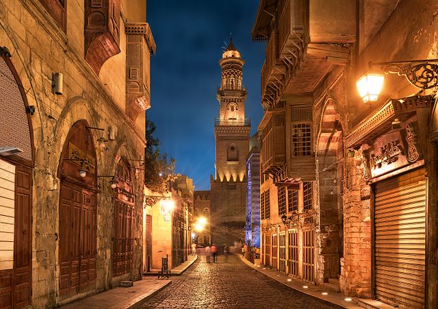
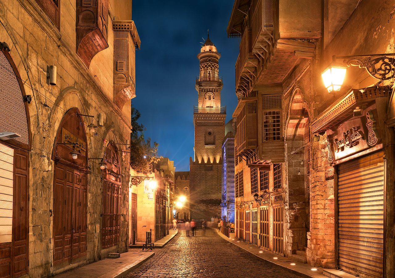
English: Old cairo between history and future.jpg Essam Azzam St. (Shariʻa al-Muizz li-Deen Illah) (30°02′ 48" N 31°15′ 36"E) in Islamic Cairo, Egypt is one of the oldest streets in Cairo, approximately one kilometer long. A United Nations study found it to have the greatest concentration of medieval architectural treasures in the Islamic world.[1] The street (shariʻa in Arabic) is named for Al-Muʿizz li-Deen Illah, the fourth caliph of the Fatimid dynasty. It stretches from Bab Al-Futuh in the north to Bab Zuweila in the south. Starting in 1997,[2][3] the national government carried out extensive renovations to the historical buildings, modern buildings, paving, and sewerage to turn the street into an "open-air museum". On April 24, 2008, Al-Muizz Street was rededicated as a pedestrian only zone between 8:00 am and 11:00 pm; cargo traffic will be allowed outside of these hours.[4]
The northern part of the street extends from the Al-Hakim Mosque in the north to the Spice Market at Al-Azhar Street and includes the antiques markets section, Al-Aqmar Mosque (one of the few extant Fatimid mosques), the Qalawun complex, and several well preserved medieval mansions and palaces. |
| ᱢᱟᱹᱦᱤᱛ | |
| ᱯᱷᱮᱰᱟᱛ | ᱤᱧᱟᱜ ᱠᱟᱹᱢᱤ |
| ᱚᱱᱚᱞᱤᱭᱟᱹ | Mohammed Moussa |
| Camera location | | View this and other nearby images on: OpenStreetMap |
|---|
ᱞᱟᱭᱥᱮᱱᱥ ᱛᱮᱭᱟᱨ
I, the copyright holder of this work, hereby publish it under the following license:
This file is licensed under the Creative Commons Attribution-Share Alike 4.0 International license.
- ᱟᱲᱟᱜ ᱜᱮᱭᱟᱢ:
- ᱦᱟᱹᱴᱤᱧᱢᱮ – ᱱᱚᱠᱚᱞ ᱞᱟᱹᱜᱤᱫ, ᱦᱟᱹᱴᱤᱧ ᱟᱨ ᱵᱷᱮᱡᱟᱭᱢᱮ ᱠᱟᱹᱢᱤ
- ᱢᱮᱥᱟᱣᱠᱟᱛᱢᱮ – ᱠᱟᱹᱢᱤ ᱟᱞᱜᱟᱭ ᱞᱟᱹᱜᱤᱫ
- ᱞᱟᱛᱟᱨ ᱨᱮᱭᱟᱜ ᱨᱤᱛ ᱞᱮᱠᱟᱛᱮ:
- ᱟᱴᱨᱤᱵᱩᱥᱚᱱ – ᱟᱢ ᱠᱟᱹᱢᱤ ᱥᱚᱫᱚᱨ ᱦᱩᱭᱟᱢᱟ ᱡᱚᱠᱷᱚᱱ ᱚᱱᱚᱞᱤᱭᱟᱹ ᱟᱨᱵᱟᱝ ᱞᱟᱭᱥᱮᱸᱥᱩᱭᱟᱹ ᱫᱟᱨᱟᱭᱛᱮ ᱠᱟᱛᱷᱟ ᱨᱟᱠᱟᱵ ᱠᱷᱟᱱ (ᱢᱮᱱᱠᱷᱟᱱ ᱟᱠᱚ ᱩᱫᱩᱜᱟᱜ ᱦᱚᱨ ᱛᱮᱫᱚ ᱵᱟᱝ ᱡᱟᱦᱟᱸ ᱟᱠᱚᱠᱚ ᱜᱚᱲᱚᱣᱟᱢ ᱟᱨᱵᱟᱝ ᱟᱢᱟᱜ ᱠᱟᱹᱢᱤ ᱨᱮᱱᱟᱜ ᱵᱮᱵᱷᱟᱨ)
- ᱦᱟᱹᱴᱤᱧ ᱱᱚᱝᱠᱟ ᱜᱮ – ᱟᱢ ᱡᱩᱫᱤ ᱠᱟᱹᱢᱤ ᱵᱚᱫᱚᱞ, ᱛᱚᱨᱡᱚᱢᱟ, ᱵᱟᱝᱠᱷᱟᱱ ᱱᱚᱣᱟ ᱠᱟᱹᱢᱤ ᱪᱮᱛᱟᱱᱨᱮ ᱱᱟᱣᱟ ᱠᱟᱹᱢᱤ ᱥᱤᱨᱡᱟᱹᱣᱮᱢ ᱛᱮᱭᱟᱨ ᱠᱷᱟᱱ, ᱛᱚᱵᱮ ᱟᱢ ᱫᱚ ᱚᱱᱟ ᱠᱟᱹᱢᱤ ᱚᱱᱟ ᱢᱤᱫ ᱞᱟᱤᱥᱮᱱᱥ ᱥᱮ ᱚᱱᱟ ᱞᱮᱠᱟᱱᱟᱜ ᱞᱟᱤᱥᱮᱱᱥ ᱨᱮᱜᱮ ᱪᱟᱞ ᱦᱩᱭᱩᱜ ᱛᱟᱢᱟ᱾

|
This image was uploaded as part of Wiki Loves Monuments 2016.
|
 |
ᱨᱮᱫ ᱨᱮᱭᱟᱜ ᱱᱟᱜᱟᱢ
ᱚᱠᱛᱚ ᱨᱮ ᱞᱤᱱ ᱢᱮ/ᱚᱠᱛᱚ ᱨᱮ ᱨᱮᱫ ᱧᱮᱞ ᱞᱟᱹᱜᱤᱛ ᱞᱤᱱ ᱢᱮ
| ᱢᱟᱹᱦᱤᱛ/ᱚᱠᱛᱚ | ᱴᱤᱯ | ᱡᱚᱠᱷᱟ | ᱵᱮᱵᱷᱟᱨᱤᱭᱟᱹ | ᱠᱟᱛᱷᱟ | |
|---|---|---|---|---|---|
| ᱱᱤᱛᱚᱜ | ᱐᱐:᱑᱓, ᱓᱐ ᱥᱮᱯᱴᱮᱢᱵᱚᱨ ᱒᱐᱑᱖ | | ᱕,᱖᱘᱒ × ᱔,᱐᱐᱐ (᱑᱘.᱐᱖ MB) | M mousa 86 | User created page with UploadWizard |
ᱯᱷᱟᱭᱤᱞ ᱵᱮᱣᱦᱟᱨ
ᱞᱟᱛᱟᱨ ᱨᱮᱭᱟᱜ ᱥᱟᱦᱴᱟ ᱡᱚᱱᱚᱲᱠᱚ ᱱᱤᱭᱟᱹ ᱨᱮᱫ ᱨᱮ:
ᱡᱮᱜᱮᱛ ᱡᱟᱠᱟᱛ ᱨᱮᱫ ᱵᱮᱵᱷᱟᱨᱟᱜ
ᱱᱚᱶᱟ ᱨᱮᱫᱠᱚ ᱵᱮᱵᱷᱟᱨᱟᱠᱟᱫ ᱣᱤᱠᱤᱠᱚ :
- ar.wikipedia.org ᱨᱮ ᱵᱮᱣᱦᱟᱨ
- azb.wikipedia.org ᱨᱮ ᱵᱮᱣᱦᱟᱨ
- bcl.wikipedia.org ᱨᱮ ᱵᱮᱣᱦᱟᱨ
- bs.wikipedia.org ᱨᱮ ᱵᱮᱣᱦᱟᱨ
- csb.wikipedia.org ᱨᱮ ᱵᱮᱣᱦᱟᱨ
- el.wikipedia.org ᱨᱮ ᱵᱮᱣᱦᱟᱨ
- en.wikipedia.org ᱨᱮ ᱵᱮᱣᱦᱟᱨ
- et.wikipedia.org ᱨᱮ ᱵᱮᱣᱦᱟᱨ
- eu.wikipedia.org ᱨᱮ ᱵᱮᱣᱦᱟᱨ
- fa.wikipedia.org ᱨᱮ ᱵᱮᱣᱦᱟᱨ
- hy.wikipedia.org ᱨᱮ ᱵᱮᱣᱦᱟᱨ
- id.wikipedia.org ᱨᱮ ᱵᱮᱣᱦᱟᱨ
- inh.wikipedia.org ᱨᱮ ᱵᱮᱣᱦᱟᱨ
- ja.wikipedia.org ᱨᱮ ᱵᱮᱣᱦᱟᱨ
- lt.wikipedia.org ᱨᱮ ᱵᱮᱣᱦᱟᱨ
- mai.wikipedia.org ᱨᱮ ᱵᱮᱣᱦᱟᱨ
- ne.wikipedia.org ᱨᱮ ᱵᱮᱣᱦᱟᱨ
- pnb.wikipedia.org ᱨᱮ ᱵᱮᱣᱦᱟᱨ
- ps.wikipedia.org ᱨᱮ ᱵᱮᱣᱦᱟᱨ
- pt.wikipedia.org ᱨᱮ ᱵᱮᱣᱦᱟᱨ
- ru.wikipedia.org ᱨᱮ ᱵᱮᱣᱦᱟᱨ
- sd.wikipedia.org ᱨᱮ ᱵᱮᱣᱦᱟᱨ
- simple.wikipedia.org ᱨᱮ ᱵᱮᱣᱦᱟᱨ
- sr.wikipedia.org ᱨᱮ ᱵᱮᱣᱦᱟᱨ
- te.wikipedia.org ᱨᱮ ᱵᱮᱣᱦᱟᱨ
- th.wikipedia.org ᱨᱮ ᱵᱮᱣᱦᱟᱨ
- tr.wikipedia.org ᱨᱮ ᱵᱮᱣᱦᱟᱨ
- uk.wikipedia.org ᱨᱮ ᱵᱮᱣᱦᱟᱨ
- ur.wikipedia.org ᱨᱮ ᱵᱮᱣᱦᱟᱨ
- uz.wikipedia.org ᱨᱮ ᱵᱮᱣᱦᱟᱨ
- zh.wikipedia.org ᱨᱮ ᱵᱮᱣᱦᱟᱨ
- zu.wikipedia.org ᱨᱮ ᱵᱮᱣᱦᱟᱨ