ᱨᱮᱫ:NASA-GNT.jpg
ᱧᱮᱞᱡᱚᱝ ᱨᱮᱱᱟᱜ ᱟᱠᱟᱨ:᱖᱐᱖ × ᱕᱙᱙ ᱯᱤᱠᱥᱮᱞ ᱮᱴᱟᱜ ᱨᱤᱡᱚᱞᱩᱥᱚᱱᱥ: ᱒᱔᱓ × ᱒᱔᱐ ᱯᱤᱠᱥᱮᱞ | ᱔᱘᱕ × ᱔᱘᱐ ᱯᱤᱠᱥᱮᱞ | ᱖᱔᱐ × ᱖᱓᱓ ᱯᱤᱠᱥᱮᱞ
ᱟᱥᱚᱞ ᱨᱮᱫ (᱖᱔᱐ x ᱖᱓᱓ pixels, file size: ᱑᱐᱐ KB, MIME type: image/jpeg)
ᱢᱩᱬᱩᱛ ᱠᱟᱛᱷᱟ
| ᱵᱤᱵᱚᱨᱚᱱᱤ |
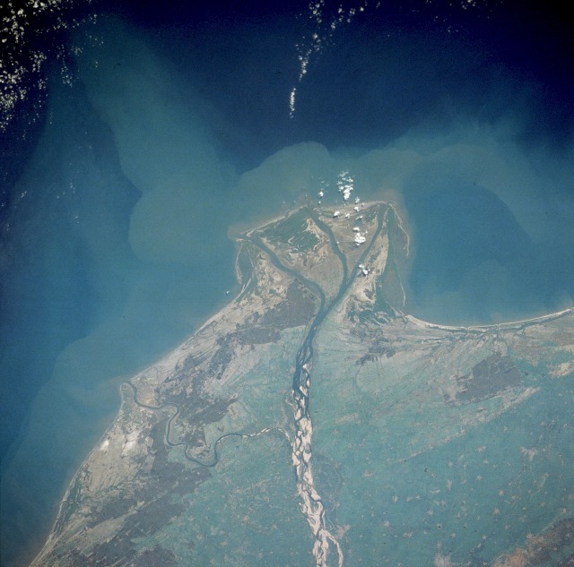
English: With the Ocean on the top portion of the Image, the actual location of the Guntur City should be on the bottom right side portion of the Image.
|
| ᱢᱟᱹᱦᱤᱛ | Taken on ᱑᱑ ᱡᱟᱱᱩᱣᱟᱨᱤ ᱑᱙᱙᱐, ᱐᱕:᱕᱑:᱔᱑ UTC |
| ᱯᱷᱮᱰᱟᱛ | https://eol.jsc.nasa.gov/searchphotos/photo.pl?mission=STS032&roll=72&frame=61 |
| ᱚᱱᱚᱞᱤᱭᱟᱹ | NASA |
| Other versions |
|

This image or video was catalogued by one of the centers of the United States National Aeronautics and Space Administration (NASA) under Photo ID: STS-032-72-61. This tag does not indicate the copyright status of the attached work. A normal copyright tag is still required. See Commons:Licensing. Other languages:
|
ᱞᱟᱭᱥᱮᱱᱥ ᱛᱮᱭᱟᱨ
| This file is in the public domain in the United States because it was solely created by NASA. NASA copyright policy states that "NASA material is not protected by copyright unless noted". (See Template:PD-USGov, NASA copyright policy page or JPL Image Use Policy.) | ||
 |
Warnings:
|
Original upload log
The original description page was here. All following user names refer to en.wikipedia.
Transferred from en.wikipedia to Commons by Kajasudhakarababu using CommonsHelper.
- 2006-05-10 14:25 Gnt 640×633×8 (102625 bytes) Souce: http://eol.jsc.nasa.gov/sseop/EFS/photoinfo.pl?PHOTO=STS032-72-61 From NASA.
ᱨᱮᱫ ᱨᱮᱭᱟᱜ ᱱᱟᱜᱟᱢ
ᱚᱠᱛᱚ ᱨᱮ ᱞᱤᱱ ᱢᱮ/ᱚᱠᱛᱚ ᱨᱮ ᱨᱮᱫ ᱧᱮᱞ ᱞᱟᱹᱜᱤᱛ ᱞᱤᱱ ᱢᱮ
| ᱢᱟᱹᱦᱤᱛ/ᱚᱠᱛᱚ | ᱴᱤᱯ | ᱡᱚᱠᱷᱟ | ᱵᱮᱵᱷᱟᱨᱤᱭᱟᱹ | ᱠᱟᱛᱷᱟ | |
|---|---|---|---|---|---|
| ᱱᱤᱛᱚᱜ | ᱑᱔:᱓᱖, ᱘ ᱡᱩᱞᱟᱭ ᱒᱐᱐᱘ | | ᱖᱔᱐ × ᱖᱓᱓ (᱑᱐᱐ KB) | File Upload Bot (Magnus Manske) | {{BotMoveToCommons|en.wikipedia}} {{Information |Description={{en|Souce: http://eol.jsc.nasa.gov/sseop/EFS/photoinfo.pl?PHOTO=STS032-72-61 From NASA. With the Ocean on the top portion of the Image, the actual location of the '''[[:en:Guntur|Guntur City] |
ᱯᱷᱟᱭᱤᱞ ᱵᱮᱣᱦᱟᱨ
ᱞᱟᱛᱟᱨ ᱨᱮᱭᱟᱜ ᱥᱟᱦᱴᱟ ᱡᱚᱱᱚᱲᱠᱚ ᱱᱤᱭᱟᱹ ᱨᱮᱫ ᱨᱮ:
ᱡᱮᱜᱮᱛ ᱡᱟᱠᱟᱛ ᱨᱮᱫ ᱵᱮᱵᱷᱟᱨᱟᱜ
ᱱᱚᱶᱟ ᱨᱮᱫᱠᱚ ᱵᱮᱵᱷᱟᱨᱟᱠᱟᱫ ᱣᱤᱠᱤᱠᱚ :
- bn.wikipedia.org ᱨᱮ ᱵᱮᱣᱦᱟᱨ
- en.wikipedia.org ᱨᱮ ᱵᱮᱣᱦᱟᱨ
- es.wikipedia.org ᱨᱮ ᱵᱮᱣᱦᱟᱨ
- fr.wikipedia.org ᱨᱮ ᱵᱮᱣᱦᱟᱨ
- te.wikipedia.org ᱨᱮ ᱵᱮᱣᱦᱟᱨ