ᱨᱮᱫ:Txu-oclc-6614368-nk52-3.jpg

ᱧᱮᱞᱡᱚᱝ ᱨᱮᱱᱟᱜ ᱟᱠᱟᱨ:᱗᱘᱒ × ᱖᱐᱐ ᱯᱤᱠᱥᱮᱞ ᱮᱴᱟᱜ ᱨᱤᱡᱚᱞᱩᱥᱚᱱᱥ: ᱓᱑᱓ × ᱒᱔᱐ ᱯᱤᱠᱥᱮᱞ | ᱖᱒᱖ × ᱔᱘᱐ ᱯᱤᱠᱥᱮᱞ | ᱑,᱐᱐᱑ × ᱗᱖᱘ ᱯᱤᱠᱥᱮᱞ | ᱑,᱒᱘᱐ × ᱙᱘᱒ ᱯᱤᱠᱥᱮᱞ | ᱒,᱕᱖᱐ × ᱑,᱙᱖᱔ ᱯᱤᱠᱥᱮᱞ | ᱕,᱐᱐᱐ × ᱓,᱘᱓᱖ ᱯᱤᱠᱥᱮᱞ
ᱟᱥᱚᱞ ᱨᱮᱫ (᱕,᱐᱐᱐ x ᱓,᱘᱓᱖ pixels, file size: ᱖.᱒᱓ MB, MIME type: image/jpeg)
ᱢᱩᱬᱩᱛ ᱠᱟᱛᱷᱟ
| ᱵᱤᱵᱚᱨᱚᱱᱤ |
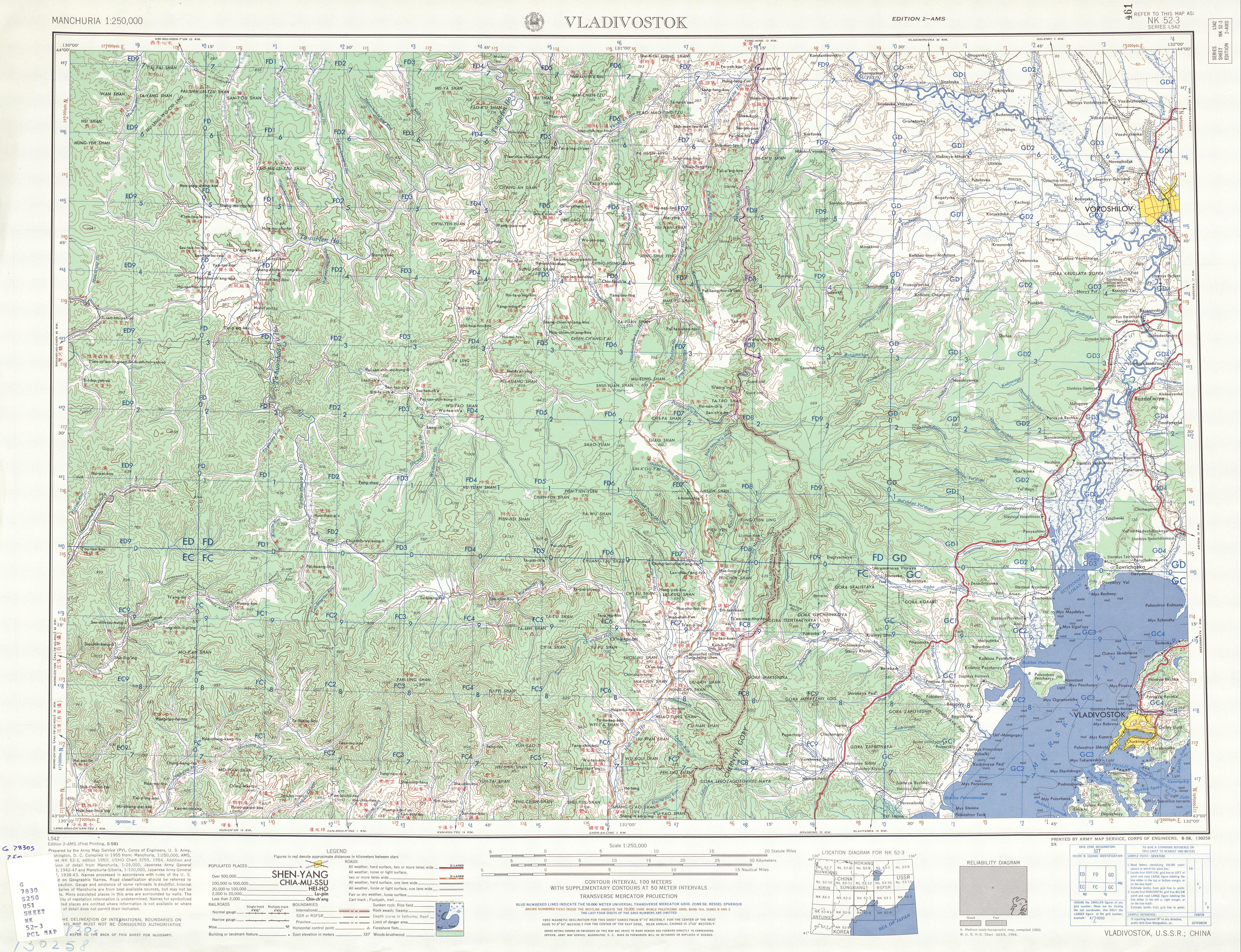
English: Map of Vladivostok area, USSR (present-day Russia) |
| ᱢᱟᱹᱦᱤᱛ | |
| ᱯᱷᱮᱰᱟᱛ | http://legacy.lib.utexas.edu/maps/ams/manchuria/txu-oclc-6614368-nk52-3.jpg |
| ᱚᱱᱚᱞᱤᱭᱟᱹ | Army Map Serivce (PV), Corps of Engineers 1955 |
-
 Index Map

ᱞᱟᱭᱥᱮᱱᱥ ᱛᱮᱭᱟᱨ
This image or file is a work of a U.S. Army Corps of Engineers soldier or employee, taken or made as part of that person's official duties. As a work of the U.S. federal government, the image is in the public domain.
|
ᱨᱮᱫ ᱨᱮᱭᱟᱜ ᱱᱟᱜᱟᱢ
ᱚᱠᱛᱚ ᱨᱮ ᱞᱤᱱ ᱢᱮ/ᱚᱠᱛᱚ ᱨᱮ ᱨᱮᱫ ᱧᱮᱞ ᱞᱟᱹᱜᱤᱛ ᱞᱤᱱ ᱢᱮ
| ᱢᱟᱹᱦᱤᱛ/ᱚᱠᱛᱚ | ᱴᱤᱯ | ᱡᱚᱠᱷᱟ | ᱵᱮᱵᱷᱟᱨᱤᱭᱟᱹ | ᱠᱟᱛᱷᱟ | |
|---|---|---|---|---|---|
| ᱱᱤᱛᱚᱜ | ᱐᱑:᱕᱙, ᱑᱑ ᱥᱮᱯᱴᱮᱢᱵᱚᱨ ᱒᱐᱑᱙ | | ᱕,᱐᱐᱐ × ᱓,᱘᱓᱖ (᱖.᱒᱓ MB) | Geographyinitiative | User created page with UploadWizard |
ᱯᱷᱟᱭᱤᱞ ᱵᱮᱣᱦᱟᱨ
ᱞᱟᱛᱟᱨ ᱨᱮᱭᱟᱜ ᱥᱟᱦᱴᱟ ᱡᱚᱱᱚᱲᱠᱚ ᱱᱤᱭᱟᱹ ᱨᱮᱫ ᱨᱮ:
ᱡᱮᱜᱮᱛ ᱡᱟᱠᱟᱛ ᱨᱮᱫ ᱵᱮᱵᱷᱟᱨᱟᱜ
ᱱᱚᱶᱟ ᱨᱮᱫᱠᱚ ᱵᱮᱵᱷᱟᱨᱟᱠᱟᱫ ᱣᱤᱠᱤᱠᱚ :
- en.wikipedia.org ᱨᱮ ᱵᱮᱣᱦᱟᱨ
- vi.wikipedia.org ᱨᱮ ᱵᱮᱣᱦᱟᱨ