ᱨᱮᱫ:Ap-districts.png

ᱧᱮᱞᱡᱚᱝ ᱨᱮᱱᱟᱜ ᱟᱠᱟᱨ:᱗᱒᱒ × ᱖᱐᱐ ᱯᱤᱠᱥᱮᱞ ᱮᱴᱟᱜ ᱨᱤᱡᱚᱞᱩᱥᱚᱱᱥ: ᱒᱘᱙ × ᱒᱔᱐ ᱯᱤᱠᱥᱮᱞ | ᱕᱗᱘ × ᱔᱘᱐ ᱯᱤᱠᱥᱮᱞ | ᱙᱒᱕ × ᱗᱖᱘ ᱯᱤᱠᱥᱮᱞ | ᱑,᱒᱓᱓ × ᱑,᱐᱒᱔ ᱯᱤᱠᱥᱮᱞ | ᱒,᱔᱘᱗ × ᱒,᱐᱖᱖ ᱯᱤᱠᱥᱮᱞ
ᱟᱥᱚᱞ ᱨᱮᱫ (᱒,᱔᱘᱗ x ᱒,᱐᱖᱖ pixels, file size: ᱗᱑᱔ KB, MIME type: image/png)
| ᱵᱤᱵᱚᱨᱚᱱᱤ |
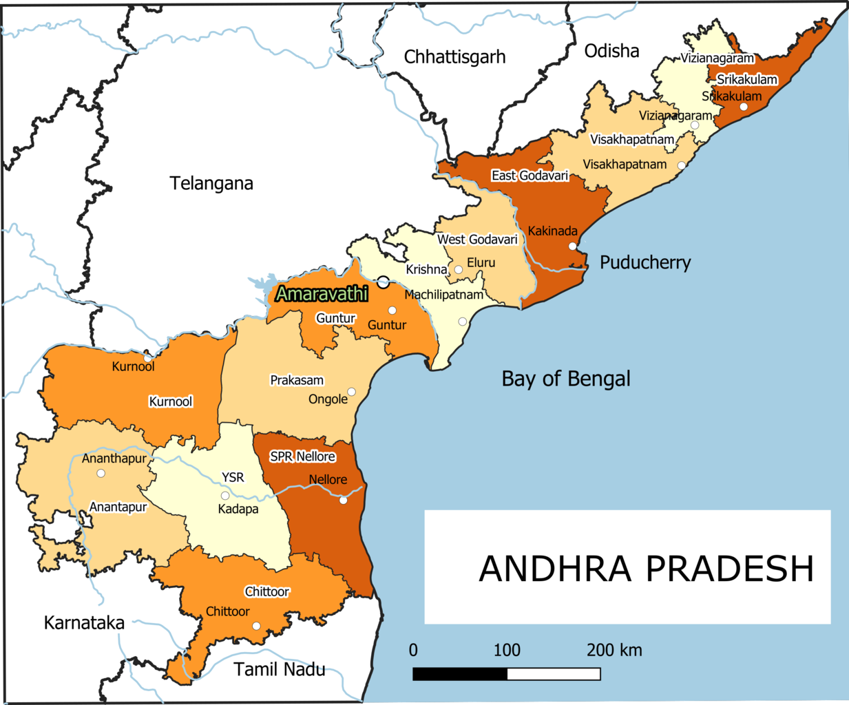
English: Old Andhra Pradesh Map
For more information please see: File:ఆంధ్రప్రదేశ్ జిల్లాల పటము.png |
| ᱢᱟᱹᱦᱤᱛ | |
| ᱯᱷᱮᱰᱟᱛ | ᱤᱧᱟᱜ ᱠᱟᱹᱢᱤ |
| ᱚᱱᱚᱞᱤᱭᱟᱹ | Arjunaraoc |
| Other versions | For the latest version see File:Ap-districts.svg |
; for older version see https://commons.wikimedia.org/w/index.php?title=File:Map_AP_dist_all_shaded.png&oldid=344558866 ,
ᱞᱟᱭᱥᱮᱱᱥ ᱛᱮᱭᱟᱨ
I, the copyright holder of this work, hereby publish it under the following license:
| This work contains information from OpenStreetMap, which is made available under the Open Database License (ODbL).
The ODbL does not require any particular license for maps produced from ODbL data. Prior to 1 August 2020, map tiles produced by the OpenStreetMap Foundation were licensed under the CC-BY-SA-2.0 license. Maps produced by other people may be subject to other licences. |
ᱨᱮᱫ ᱨᱮᱭᱟᱜ ᱱᱟᱜᱟᱢ
ᱚᱠᱛᱚ ᱨᱮ ᱞᱤᱱ ᱢᱮ/ᱚᱠᱛᱚ ᱨᱮ ᱨᱮᱫ ᱧᱮᱞ ᱞᱟᱹᱜᱤᱛ ᱞᱤᱱ ᱢᱮ
| ᱢᱟᱹᱦᱤᱛ/ᱚᱠᱛᱚ | ᱴᱤᱯ | ᱡᱚᱠᱷᱟ | ᱵᱮᱵᱷᱟᱨᱤᱭᱟᱹ | ᱠᱟᱛᱷᱟ | |
|---|---|---|---|---|---|
| ᱱᱤᱛᱚᱜ | ᱑᱒:᱑᱒, ᱒᱕ ᱰᱤᱥᱮᱢᱵᱚᱨ ᱒᱐᱒᱑ | | ᱒,᱔᱘᱗ × ᱒,᱐᱖᱖ (᱗᱑᱔ KB) | Arjunaraoc | Created new version with clean state boundaries using OSM and natural earth data |
| ᱐᱙:᱒᱙, ᱒᱗ ᱢᱟᱨᱪ ᱒᱐᱑᱙ |  | ᱒,᱔᱘᱕ × ᱒,᱐᱖᱔ (᱗᱗᱐ KB) | Arjunaraoc | fixed few labels going outside graphic | |
| ᱐᱘:᱐᱑, ᱒᱗ ᱢᱟᱨᱪ ᱒᱐᱑᱙ |  | ᱒,᱔᱘᱕ × ᱒,᱐᱖᱔ (᱗᱗᱐ KB) | Arjunaraoc | Corrected the boundaries of Andhra Pradesh districts impacted by State division in 2014. For more information check details in File:ఆంధ్రప్రదేశ్ జిల్లాల పటము.png | |
| ᱐᱘:᱒᱑, ᱒ ᱱᱚᱵᱷᱮᱢᱵᱚᱨ ᱒᱐᱑᱕ |  | ᱖᱐᱐ × ᱖᱐᱐ (᱗᱖ KB) | Kannadabheri | Cross-wiki upload from en.wikipedia.org |
ᱯᱷᱟᱭᱤᱞ ᱵᱮᱣᱦᱟᱨ
ᱞᱟᱛᱟᱨ ᱨᱮᱭᱟᱜ ᱥᱟᱦᱴᱟ ᱡᱚᱱᱚᱲᱠᱚ ᱱᱤᱭᱟᱹ ᱨᱮᱫ ᱨᱮ:
ᱡᱮᱜᱮᱛ ᱡᱟᱠᱟᱛ ᱨᱮᱫ ᱵᱮᱵᱷᱟᱨᱟᱜ
ᱱᱚᱶᱟ ᱨᱮᱫᱠᱚ ᱵᱮᱵᱷᱟᱨᱟᱠᱟᱫ ᱣᱤᱠᱤᱠᱚ :
- bn.wikipedia.org ᱨᱮ ᱵᱮᱣᱦᱟᱨ
- ha.wikipedia.org ᱨᱮ ᱵᱮᱣᱦᱟᱨ
- hi.wikipedia.org ᱨᱮ ᱵᱮᱣᱦᱟᱨ
- hu.wikipedia.org ᱨᱮ ᱵᱮᱣᱦᱟᱨ
- oc.wikipedia.org ᱨᱮ ᱵᱮᱣᱦᱟᱨ
- sd.wikipedia.org ᱨᱮ ᱵᱮᱣᱦᱟᱨ
- tcy.wikipedia.org ᱨᱮ ᱵᱮᱣᱦᱟᱨ