ᱨᱮᱫ:Florida topographic map-en.svg

Size of this PNG preview of this SVG file: ᱖᱑᱗ × ᱖᱐᱐ ᱯᱤᱠᱥᱮᱞ. ᱮᱴᱟᱜ ᱨᱤᱡᱚᱞᱩᱥᱚᱱᱥ: ᱒᱔᱗ × ᱒᱔᱐ ᱯᱤᱠᱥᱮᱞ | ᱔᱙᱔ × ᱔᱘᱐ ᱯᱤᱠᱥᱮᱞ | ᱗᱙᱐ × ᱗᱖᱘ ᱯᱤᱠᱥᱮᱞ | ᱑,᱐᱕᱓ × ᱑,᱐᱒᱔ ᱯᱤᱠᱥᱮᱞ | ᱒,᱑᱐᱖ × ᱒,᱐᱔᱘ ᱯᱤᱠᱥᱮᱞ | ᱒,᱘᱙᱐ × ᱒,᱘᱑᱐ ᱯᱤᱠᱥᱮᱞ
ᱟᱥᱚᱞ ᱨᱮᱫ (SVG ᱨᱮᱫ, ᱱᱚᱨᱢᱟᱞᱛᱮ ᱒,᱘᱙᱐ x ᱒,᱘᱑᱐ pixels, ᱨᱮᱫ ᱡᱟᱜᱟ: ᱒.᱕᱑ MB)
|

ᱢᱩᱬᱩᱛ ᱠᱟᱛᱷᱟ
| Description |
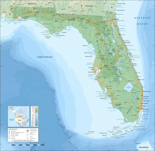
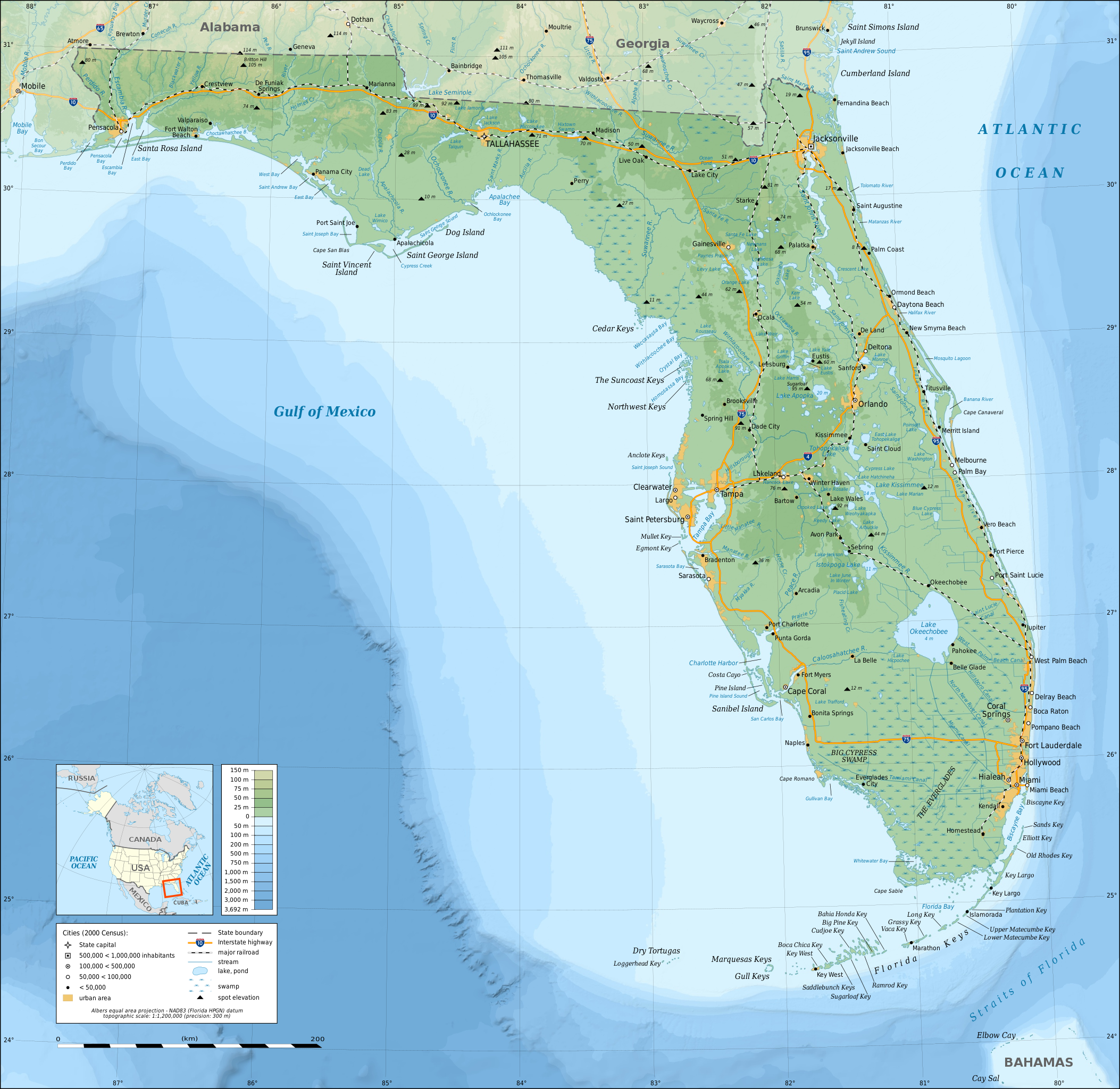
English: Topographic map of the State of Florida, USA (2000 Census).
Note: the background map is a raster image embedded in the SVG file. Español: Mapa topográfico del estado de Florida, Estados Unidos (censo del 2000).
Nota: el fondo del mapa es una imagen incrustada en el archivo SVG. Français : Carte topographique de l'état de Floride, États-Unis (recensement 2000). Note : le fond de carte est une image bitmap embarquée dans le fichier SVG. Albers equal area projection; NAD83 (Florida HPGN) datum |
||
| ᱢᱟᱹᱦᱤᱛ | |||
| ᱯᱷᱮᱰᱟᱛ |
ᱤᱧᱟᱜ ᱠᱟᱹᱢᱤ
|
||
| Creator | |||
| ᱟᱹᱭᱫᱟᱹᱨᱤ (ᱱᱚᱣᱟ ᱨᱮᱫ ᱫᱚᱲᱦᱟᱛᱮ ᱵᱮᱵᱷᱟᱨ) |
|
||
| Georeferencing | If inappropriate please set warp_status = skip to hide. | ||
| Other versions |
[]
|


|
This SVG file contains embedded text that can be translated into your language, using any capable SVG editor, text editor or the SVG Translate tool. For more information see: About translating SVG files. |
ᱞᱟᱭᱥᱮᱱᱥ ᱛᱮᱭᱟᱨ
I, the copyright holder of this work, hereby publish it under the following licenses:

|
ᱫᱟᱣ ᱮᱢᱮᱱᱟ ᱱᱚᱠᱚᱞ, ᱦᱟᱹᱴᱤᱧ ᱟᱨ/ᱟᱨᱵᱟᱝ ᱟᱹᱨᱩᱯᱷᱮᱨᱟᱣ ᱞᱟᱹᱜᱤᱫ ᱱᱚᱶᱟ ᱱᱩᱛᱷᱤ ᱠᱚ GNU Free Documentation License ᱟᱹᱨᱤ ᱛᱮ, ᱵᱷᱟᱨᱥᱚᱱ ᱑.᱒ ᱟᱨᱵᱟᱝ ᱡᱟᱦᱟᱸᱜᱮ ᱛᱟᱭᱚᱢᱟᱜ ᱵᱷᱟᱨᱥᱚᱱ Free Software Foundation ᱫᱟᱨᱟᱭᱛᱮ ᱩᱪᱷᱟᱹᱱ ᱟᱠᱟᱱ; ᱵᱤᱱ ᱵᱷᱮᱯᱮᱜᱮᱫ ᱦᱟᱹᱴᱤᱧ, ᱵᱤᱱ ᱥᱟᱢᱟᱝ ᱚᱞᱠᱚ, ᱟᱨ ᱵᱤᱱ ᱯᱟᱹᱪᱷᱞᱟᱹ ᱚᱞᱠᱚ ᱥᱟᱶᱛᱮ ᱾ ᱢᱤᱫ GNU Free Documentation License ᱧᱩᱛᱩᱢᱟᱱ ᱞᱟᱭᱥᱮᱸᱥ ᱨᱮᱱᱟᱜ ᱱᱚᱠᱚᱞ ᱡᱚᱲᱟᱣᱮᱱᱟ ᱾ |
This file is licensed under the Creative Commons Attribution-Share Alike Attribution-Share Alike 4.0 International, 3.0 Unported, 2.5 Generic, 2.0 Generic and 1.0 Generic license.
- ᱟᱲᱟᱜ ᱜᱮᱭᱟᱢ:
- ᱦᱟᱹᱴᱤᱧᱢᱮ – ᱱᱚᱠᱚᱞ ᱞᱟᱹᱜᱤᱫ, ᱦᱟᱹᱴᱤᱧ ᱟᱨ ᱵᱷᱮᱡᱟᱭᱢᱮ ᱠᱟᱹᱢᱤ
- ᱢᱮᱥᱟᱣᱠᱟᱛᱢᱮ – ᱠᱟᱹᱢᱤ ᱟᱞᱜᱟᱭ ᱞᱟᱹᱜᱤᱫ
- ᱞᱟᱛᱟᱨ ᱨᱮᱭᱟᱜ ᱨᱤᱛ ᱞᱮᱠᱟᱛᱮ:
- ᱟᱴᱨᱤᱵᱩᱥᱚᱱ – ᱟᱢ ᱠᱟᱹᱢᱤ ᱥᱚᱫᱚᱨ ᱦᱩᱭᱟᱢᱟ ᱡᱚᱠᱷᱚᱱ ᱚᱱᱚᱞᱤᱭᱟᱹ ᱟᱨᱵᱟᱝ ᱞᱟᱭᱥᱮᱸᱥᱩᱭᱟᱹ ᱫᱟᱨᱟᱭᱛᱮ ᱠᱟᱛᱷᱟ ᱨᱟᱠᱟᱵ ᱠᱷᱟᱱ (ᱢᱮᱱᱠᱷᱟᱱ ᱟᱠᱚ ᱩᱫᱩᱜᱟᱜ ᱦᱚᱨ ᱛᱮᱫᱚ ᱵᱟᱝ ᱡᱟᱦᱟᱸ ᱟᱠᱚᱠᱚ ᱜᱚᱲᱚᱣᱟᱢ ᱟᱨᱵᱟᱝ ᱟᱢᱟᱜ ᱠᱟᱹᱢᱤ ᱨᱮᱱᱟᱜ ᱵᱮᱵᱷᱟᱨ)
- ᱦᱟᱹᱴᱤᱧ ᱱᱚᱝᱠᱟ ᱜᱮ – ᱟᱢ ᱡᱩᱫᱤ ᱠᱟᱹᱢᱤ ᱵᱚᱫᱚᱞ, ᱛᱚᱨᱡᱚᱢᱟ, ᱵᱟᱝᱠᱷᱟᱱ ᱱᱚᱣᱟ ᱠᱟᱹᱢᱤ ᱪᱮᱛᱟᱱᱨᱮ ᱱᱟᱣᱟ ᱠᱟᱹᱢᱤ ᱥᱤᱨᱡᱟᱹᱣᱮᱢ ᱛᱮᱭᱟᱨ ᱠᱷᱟᱱ, ᱛᱚᱵᱮ ᱟᱢ ᱫᱚ ᱚᱱᱟ ᱠᱟᱹᱢᱤ ᱚᱱᱟ ᱢᱤᱫ ᱞᱟᱤᱥᱮᱱᱥ ᱥᱮ ᱚᱱᱟ ᱞᱮᱠᱟᱱᱟᱜ ᱞᱟᱤᱥᱮᱱᱥ ᱨᱮᱜᱮ ᱪᱟᱞ ᱦᱩᱭᱩᱜ ᱛᱟᱢᱟ᱾
ᱟᱢᱟᱜ ᱠᱩᱥᱤ ᱞᱮᱠᱟᱛᱮ ᱞᱟᱭᱥᱮᱱᱥ ᱵᱟᱪᱷᱟᱣ ᱫᱟᱲᱮᱭᱟᱜ ᱟᱢ᱾
ᱨᱮᱫ ᱨᱮᱭᱟᱜ ᱱᱟᱜᱟᱢ
ᱚᱠᱛᱚ ᱨᱮ ᱞᱤᱱ ᱢᱮ/ᱚᱠᱛᱚ ᱨᱮ ᱨᱮᱫ ᱧᱮᱞ ᱞᱟᱹᱜᱤᱛ ᱞᱤᱱ ᱢᱮ
| ᱢᱟᱹᱦᱤᱛ/ᱚᱠᱛᱚ | ᱴᱤᱯ | ᱡᱚᱠᱷᱟ | ᱵᱮᱵᱷᱟᱨᱤᱭᱟᱹ | ᱠᱟᱛᱷᱟ | |
|---|---|---|---|---|---|
| ᱱᱤᱛᱚᱜ | ᱑᱕:᱒᱖, ᱑᱖ ᱰᱤᱥᱮᱢᱵᱚᱨ ᱒᱐᱐᱘ | | ᱒,᱘᱙᱐ × ᱒,᱘᱑᱐ (᱒.᱕᱑ MB) | Sting | Added summits names |
| ᱐᱑:᱓᱔, ᱑᱕ ᱰᱤᱥᱮᱢᱵᱚᱨ ᱒᱐᱐᱘ |  | ᱒,᱘᱙᱐ × ᱒,᱘᱑᱐ (᱒.᱕᱑ MB) | Sting | == Summary == {{Information |Description={{en|Topographic map of the State of Florida, USA (2000 Census).<br/>''Note: the background map is a raster image embedded in the SVG file.''} |
ᱯᱷᱟᱭᱤᱞ ᱵᱮᱣᱦᱟᱨ
ᱞᱟᱛᱟᱨ ᱨᱮᱭᱟᱜ ᱥᱟᱦᱴᱟ ᱡᱚᱱᱚᱲᱠᱚ ᱱᱤᱭᱟᱹ ᱨᱮᱫ ᱨᱮ:
ᱡᱮᱜᱮᱛ ᱡᱟᱠᱟᱛ ᱨᱮᱫ ᱵᱮᱵᱷᱟᱨᱟᱜ
ᱱᱚᱶᱟ ᱨᱮᱫᱠᱚ ᱵᱮᱵᱷᱟᱨᱟᱠᱟᱫ ᱣᱤᱠᱤᱠᱚ :
- af.wikipedia.org ᱨᱮ ᱵᱮᱣᱦᱟᱨ
- ang.wikipedia.org ᱨᱮ ᱵᱮᱣᱦᱟᱨ
- arz.wikipedia.org ᱨᱮ ᱵᱮᱣᱦᱟᱨ
- az.wikipedia.org ᱨᱮ ᱵᱮᱣᱦᱟᱨ
- ban.wikipedia.org ᱨᱮ ᱵᱮᱣᱦᱟᱨ
- be.wikipedia.org ᱨᱮ ᱵᱮᱣᱦᱟᱨ
- bn.wikipedia.org ᱨᱮ ᱵᱮᱣᱦᱟᱨ
- ca.wikipedia.org ᱨᱮ ᱵᱮᱣᱦᱟᱨ
- de.wikipedia.org ᱨᱮ ᱵᱮᱣᱦᱟᱨ
- el.wikipedia.org ᱨᱮ ᱵᱮᱣᱦᱟᱨ
- en.wikipedia.org ᱨᱮ ᱵᱮᱣᱦᱟᱨ
- Portal:Geography
- Portal:Geography/Featured picture
- Portal:Florida
- User talk:Sting
- Wikipedia:Graphics Lab/Resources/Tutorials
- Wikipedia:Featured pictures/Diagrams, drawings, and maps/Maps
- Geography of Florida
- Florida
- Wikipedia:WikiProject United States/Recognized content
- Wikipedia:Featured pictures thumbs/26
- Wikipedia:WikiProject United States/Quality content
- User talk:Jujutacular/Archive 9
- Wikipedia:Featured picture candidates/December-2010
- Wikipedia:Featured picture candidates/Topographic map of Florida
- Talk:Geography of Florida
- Template:POTD/2013-03-03
- Portal:Geography/Featured picture/4
- Wikipedia:Picture of the day/March 2013
- User talk:Jujutacular/Archive 15
- Wikipedia:Main Page history/2013 March 3
- User:Abyssal/bla
- Portal:Geography/Selected picture
- Wikipedia:WikiProject United States/Featured pictures
- es.wikipedia.org ᱨᱮ ᱵᱮᱣᱦᱟᱨ
- fr.wikipedia.org ᱨᱮ ᱵᱮᱣᱦᱟᱨ
- fy.wikipedia.org ᱨᱮ ᱵᱮᱣᱦᱟᱨ
- ga.wikipedia.org ᱨᱮ ᱵᱮᱣᱦᱟᱨ
- gl.wikipedia.org ᱨᱮ ᱵᱮᱣᱦᱟᱨ
- gn.wikipedia.org ᱨᱮ ᱵᱮᱣᱦᱟᱨ
- hu.wikipedia.org ᱨᱮ ᱵᱮᱣᱦᱟᱨ
- hy.wikipedia.org ᱨᱮ ᱵᱮᱣᱦᱟᱨ
- hyw.wikipedia.org ᱨᱮ ᱵᱮᱣᱦᱟᱨ
- io.wikipedia.org ᱨᱮ ᱵᱮᱣᱦᱟᱨ
ᱱᱚᱶᱟ ᱨᱮᱫ ᱨᱮᱱᱟᱜ ᱵᱟᱹᱲᱛᱤ ᱡᱮᱜᱮᱛ ᱵᱮᱵᱷᱟᱨ ᱧᱮᱞ ᱢᱮ ᱾