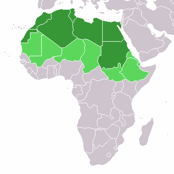
ᱨᱮᱫ:LocationNorthernAfrica.png
LocationNorthernAfrica.png (᱓᱕᱙ x ᱓᱕᱙ pixels, file size: ᱘ KB, MIME type: image/png)
ᱨᱮᱫ ᱨᱮᱭᱟᱜ ᱱᱟᱜᱟᱢ
ᱚᱠᱛᱚ ᱨᱮ ᱞᱤᱱ ᱢᱮ/ᱚᱠᱛᱚ ᱨᱮ ᱨᱮᱫ ᱧᱮᱞ ᱞᱟᱹᱜᱤᱛ ᱞᱤᱱ ᱢᱮ
| ᱢᱟᱹᱦᱤᱛ/ᱚᱠᱛᱚ | ᱴᱤᱯ | ᱡᱚᱠᱷᱟ | ᱵᱮᱵᱷᱟᱨᱤᱭᱟᱹ | ᱠᱟᱛᱷᱟ | |
|---|---|---|---|---|---|
| ᱱᱤᱛᱚᱜ | ᱑᱓:᱑᱖, ᱑᱑ ᱱᱚᱵᱷᱮᱢᱵᱚᱨ ᱒᱐᱒᱒ |  | ᱓᱕᱙ × ᱓᱕᱙ (᱘ KB) | ColorfulSmoke | . |
| ᱑᱑:᱕᱔, ᱑᱑ ᱱᱚᱵᱷᱮᱢᱵᱚᱨ ᱒᱐᱒᱒ |  | ᱓᱖᱐ × ᱓᱕᱙ (᱘ KB) | ColorfulSmoke | ||
| ᱑᱖:᱕᱗, ᱑᱗ ᱢᱟᱨᱪ ᱒᱐᱑᱘ |  | ᱓᱖᱐ × ᱓᱙᱒ (᱑᱐ KB) | Maphobbyist | Montenegro border | |
| ᱑᱘:᱑᱙, ᱑᱐ ᱯᱷᱮᱵᱽᱨᱩᱣᱟᱨᱤ ᱒᱐᱑᱔ |  | ᱓᱖᱐ × ᱓᱙᱒ (᱘ KB) | Knyaz-1988 | New version | |
| ᱐᱕:᱐᱕, ᱑᱒ ᱡᱟᱱᱩᱣᱟᱨᱤ ᱒᱐᱑᱓ |  | ᱓᱖᱐ × ᱓᱙᱒ (᱑᱓ KB) | Kuohatti | Reverted to version as of 21:04, 9 July 2011. According to http://unstats.un.org/unsd/methods/m49/m49regin.htm#africa UN doesn't count South Sudan in North Africa. | |
| ᱑᱒:᱔᱗, ᱒᱐ ᱡᱩᱞᱟᱭ ᱒᱐᱑᱑ |  | ᱓᱖᱐ × ᱓᱙᱒ (᱘ KB) | Kahusi | See http://unstats.un.org/unsd/methods/m49/m49regin.htm | |
| ᱒᱑:᱐᱔, ᱙ ᱡᱩᱞᱟᱭ ᱒᱐᱑᱑ |  | ᱓᱖᱐ × ᱓᱙᱒ (᱑᱓ KB) | Maphobbyist | South Sudan has become independent on July 9, 2011. Sudan and South Sudan are shown with the new international border between them. | |
| ᱑᱘:᱕᱕, ᱒᱗ ᱢᱮ ᱒᱐᱐᱙ |  | ᱓᱖᱐ × ᱓᱙᱒ (᱑᱔ KB) | Elmondo21st | Reverted to version as of 08:13, 11 December 2007 | |
| ᱑᱘:᱑᱓, ᱕ ᱮᱯᱨᱤᱞ ᱒᱐᱐᱙ |  | ᱓᱖᱐ × ᱓᱙᱒ (᱑᱔ KB) | Elmondo21st | The map of the northern Africa is about 5 main countries; Morocco, Algeria, Tunisia, Libya and Egypt. The greater northern Africa includes the Sahara countries among them Sudan. | |
| ᱐᱘:᱑᱓, ᱑᱑ ᱰᱤᱥᱮᱢᱵᱚᱨ ᱒᱐᱐᱗ |  | ᱓᱖᱐ × ᱓᱙᱒ (᱑᱔ KB) | Hoshie | added Cabinda (Angola) |
ᱯᱷᱟᱭᱤᱞ ᱵᱮᱣᱦᱟᱨ
ᱱᱚᱸᱰᱮ ᱫᱚ ᱟᱨ ᱮᱴᱟᱜ ᱥᱟᱦᱴᱟᱠᱚ ᱵᱟᱱᱩᱜ-ᱟ ᱡᱟᱸᱦᱟᱸ ᱥᱟᱶᱛᱮ ᱱᱤᱭᱟᱹ ᱨᱮᱫ ᱨᱮᱱᱟᱜ ᱡᱚᱱᱚᱲ ᱢᱮᱱᱟᱜ-ᱟ
ᱡᱮᱜᱮᱛ ᱡᱟᱠᱟᱛ ᱨᱮᱫ ᱵᱮᱵᱷᱟᱨᱟᱜ
ᱱᱚᱶᱟ ᱨᱮᱫᱠᱚ ᱵᱮᱵᱷᱟᱨᱟᱠᱟᱫ ᱣᱤᱠᱤᱠᱚ :
- ace.wikipedia.org ᱨᱮ ᱵᱮᱣᱦᱟᱨ
- af.wikipedia.org ᱨᱮ ᱵᱮᱣᱦᱟᱨ
- als.wikipedia.org ᱨᱮ ᱵᱮᱣᱦᱟᱨ
- am.wikipedia.org ᱨᱮ ᱵᱮᱣᱦᱟᱨ
- ar.wikipedia.org ᱨᱮ ᱵᱮᱣᱦᱟᱨ
- ليبيا
- جيبوتي
- موريتانيا
- تونس
- السودان
- الصحراء الغربية
- أنغولا
- أوغندا
- إسبانيا
- تشاد
- النيجر
- مالي
- السنغال
- غامبيا
- غينيا بيساو
- غينيا
- سيراليون
- ليبيريا
- غانا
- توغو
- بنين
- بوركينا فاسو
- الصومال
- كينيا
- تنزانيا
- الغابون
- زامبيا
- موزمبيق
- زيمبابوي
- البرتغال
- الكاميرون
- جمهورية الكونغو الديمقراطية
- بوتسوانا
- جنوب إفريقيا
- جمهورية إفريقيا الوسطى
- جمهورية الكونغو
- سيشل
- ناميبيا
- مدغشقر
- ليسوتو
- موريشيوس
ᱱᱚᱶᱟ ᱨᱮᱫ ᱨᱮᱱᱟᱜ ᱵᱟᱹᱲᱛᱤ ᱡᱮᱜᱮᱛ ᱵᱮᱵᱷᱟᱨ ᱧᱮᱞ ᱢᱮ ᱾


