ᱨᱮᱫ:Orissa State map.svg

Size of this PNG preview of this SVG file: ᱗᱔᱐ × ᱕᱙᱙ ᱯᱤᱠᱥᱮᱞ. ᱮᱴᱟᱜ ᱨᱤᱡᱚᱞᱩᱥᱚᱱᱥ: ᱒᱙᱖ × ᱒᱔᱐ ᱯᱤᱠᱥᱮᱞ | ᱕᱙᱓ × ᱔᱘᱐ ᱯᱤᱠᱥᱮᱞ | ᱙᱔᱘ × ᱗᱖᱘ ᱯᱤᱠᱥᱮᱞ | ᱑,᱒᱖᱔ × ᱑,᱐᱒᱔ ᱯᱤᱠᱥᱮᱞ | ᱒,᱕᱒᱙ × ᱒,᱐᱔᱘ ᱯᱤᱠᱥᱮᱞ | ᱒,᱑᱘᱔ × ᱑,᱗᱖᱙ ᱯᱤᱠᱥᱮᱞ
ᱟᱥᱚᱞ ᱨᱮᱫ (SVG ᱨᱮᱫ, ᱱᱚᱨᱢᱟᱞᱛᱮ ᱒,᱑᱘᱔ x ᱑,᱗᱖᱙ pixels, ᱨᱮᱫ ᱡᱟᱜᱟ: ᱑.᱗᱗ MB)
ᱢᱩᱬᱩᱛ ᱠᱟᱛᱷᱟ
| Title |
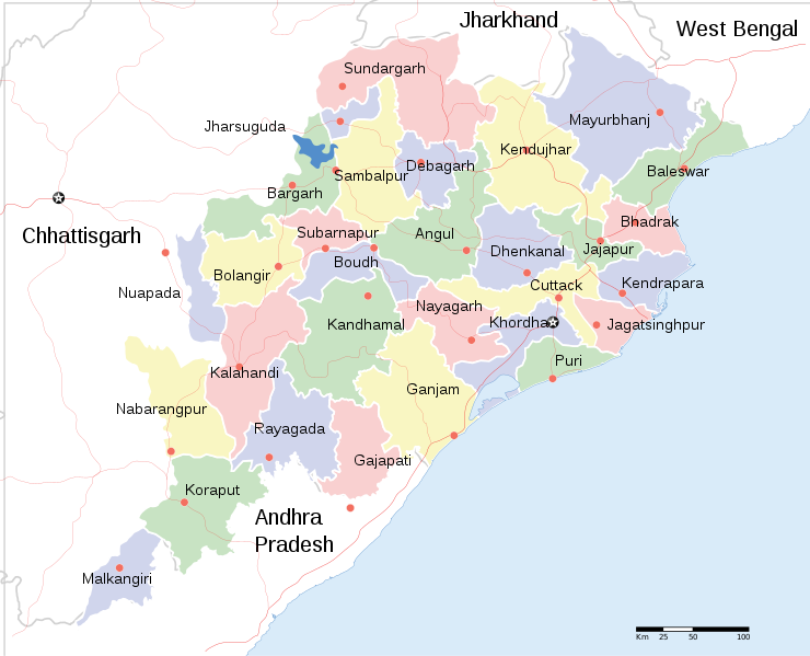
English: Locator map of Indian state, Odisha. |
| Description |
Locator map of the state of Orissa, India with district boundaries. |
| ᱢᱟᱹᱦᱤᱛ | |
| ᱯᱷᱮᱰᱟᱛ |
ᱤᱧᱟᱜ ᱠᱟᱹᱢᱤ |
| Creator | |
| ᱟᱹᱭᱫᱟᱹᱨᱤ (ᱱᱚᱣᱟ ᱨᱮᱫ ᱫᱚᱲᱦᱟᱛᱮ ᱵᱮᱵᱷᱟᱨ) |
I, the copyright holder of this work, hereby publish it under the following license: ᱱᱚᱶᱟ ᱨᱮᱫ ᱫᱚ ᱥᱟᱫᱷᱟᱨᱚᱱ ᱥᱤᱨᱡᱟᱹᱣᱟᱜ Attribution-Share Alike 3.0 Unported ᱞᱟᱭᱥᱮᱸᱥ ᱛᱟᱹᱨᱤᱨᱮ ᱢᱮᱱᱟᱜ-ᱟ ᱾
|
| Geotemporal data | |
| Date depicted | second half of 20 century ᱟᱨ 21 century |
| Georeferencing | If inappropriate please set warp_status = skip to hide. |
| Archival data | |
| Notes | Part of WikiProject India Maps |
| Other versions |
[]
|


ᱨᱮᱫ ᱨᱮᱭᱟᱜ ᱱᱟᱜᱟᱢ
ᱚᱠᱛᱚ ᱨᱮ ᱞᱤᱱ ᱢᱮ/ᱚᱠᱛᱚ ᱨᱮ ᱨᱮᱫ ᱧᱮᱞ ᱞᱟᱹᱜᱤᱛ ᱞᱤᱱ ᱢᱮ
| ᱢᱟᱹᱦᱤᱛ/ᱚᱠᱛᱚ | ᱴᱤᱯ | ᱡᱚᱠᱷᱟ | ᱵᱮᱵᱷᱟᱨᱤᱭᱟᱹ | ᱠᱟᱛᱷᱟ | |
|---|---|---|---|---|---|
| ᱱᱤᱛᱚᱜ | ᱒᱐:᱑᱘, ᱑᱐ ᱡᱩᱱ ᱒᱐᱒᱐ | | ᱒,᱑᱘᱔ × ᱑,᱗᱖᱙ (᱑.᱗᱗ MB) | শরদিন্দু ভট্টাচার্য্য | File uploaded using svgtranslate tool (https://svgtranslate.toolforge.org/). Added translation for bn. |
| ᱐᱙:᱓᱕, ᱑ ᱮᱯᱨᱤᱞ ᱒᱐᱑᱑ |  | ᱒,᱑᱘᱔ × ᱑,᱗᱖᱙ (᱑.᱗᱖ MB) | Jayantanth | == {{int:filedesc}} == {{WikiProject_India_Maps |Title=Orissa locator map |Description=Locator map of the state of Orissa, India with district boundaries. |Source= |Date=2008-12-29 |Author={{User:PlaneMad/Info}} }} [[Category:WikiPr |
ᱯᱷᱟᱭᱤᱞ ᱵᱮᱣᱦᱟᱨ
ᱱᱚᱸᱰᱮ ᱫᱚ ᱟᱨ ᱮᱴᱟᱜ ᱥᱟᱦᱴᱟᱠᱚ ᱵᱟᱱᱩᱜ-ᱟ ᱡᱟᱸᱦᱟᱸ ᱥᱟᱶᱛᱮ ᱱᱤᱭᱟᱹ ᱨᱮᱫ ᱨᱮᱱᱟᱜ ᱡᱚᱱᱚᱲ ᱢᱮᱱᱟᱜ-ᱟ
ᱡᱮᱜᱮᱛ ᱡᱟᱠᱟᱛ ᱨᱮᱫ ᱵᱮᱵᱷᱟᱨᱟᱜ
ᱱᱚᱶᱟ ᱨᱮᱫᱠᱚ ᱵᱮᱵᱷᱟᱨᱟᱠᱟᱫ ᱣᱤᱠᱤᱠᱚ :
- bcl.wikipedia.org ᱨᱮ ᱵᱮᱣᱦᱟᱨ
- bn.wikipedia.org ᱨᱮ ᱵᱮᱣᱦᱟᱨ
- cv.wikipedia.org ᱨᱮ ᱵᱮᱣᱦᱟᱨ
- en.wikipedia.org ᱨᱮ ᱵᱮᱣᱦᱟᱨ
- fa.wikipedia.org ᱨᱮ ᱵᱮᱣᱦᱟᱨ
- fr.wikipedia.org ᱨᱮ ᱵᱮᱣᱦᱟᱨ
- ha.wikipedia.org ᱨᱮ ᱵᱮᱣᱦᱟᱨ
- hr.wikipedia.org ᱨᱮ ᱵᱮᱣᱦᱟᱨ
- hy.wikipedia.org ᱨᱮ ᱵᱮᱣᱦᱟᱨ
- it.wikipedia.org ᱨᱮ ᱵᱮᱣᱦᱟᱨ
- mai.wikipedia.org ᱨᱮ ᱵᱮᱣᱦᱟᱨ
- ml.wikipedia.org ᱨᱮ ᱵᱮᱣᱦᱟᱨ
- mn.wikipedia.org ᱨᱮ ᱵᱮᱣᱦᱟᱨ
- ne.wikipedia.org ᱨᱮ ᱵᱮᱣᱦᱟᱨ
- pa.wikipedia.org ᱨᱮ ᱵᱮᱣᱦᱟᱨ
- ru.wikipedia.org ᱨᱮ ᱵᱮᱣᱦᱟᱨ
- sa.wikipedia.org ᱨᱮ ᱵᱮᱣᱦᱟᱨ
- sd.wikipedia.org ᱨᱮ ᱵᱮᱣᱦᱟᱨ
- tg.wikipedia.org ᱨᱮ ᱵᱮᱣᱦᱟᱨ
- ur.wikipedia.org ᱨᱮ ᱵᱮᱣᱦᱟᱨ
- zh.wikipedia.org ᱨᱮ ᱵᱮᱣᱦᱟᱨ
ᱱᱚᱶᱟ ᱨᱮᱫ ᱨᱮᱱᱟᱜ ᱵᱟᱹᱲᱛᱤ ᱡᱮᱜᱮᱛ ᱵᱮᱵᱷᱟᱨ ᱧᱮᱞ ᱢᱮ ᱾