ᱨᱮᱫ:South Indian territories.svg

Size of this PNG preview of this SVG file: ᱕᱔᱐ × ᱕᱙᱙ ᱯᱤᱠᱥᱮᱞ. ᱮᱴᱟᱜ ᱨᱤᱡᱚᱞᱩᱥᱚᱱᱥ: ᱒᱑᱖ × ᱒᱔᱐ ᱯᱤᱠᱥᱮᱞ | ᱔᱓᱒ × ᱔᱘᱐ ᱯᱤᱠᱥᱮᱞ | ᱖᱙᱒ × ᱗᱖᱘ ᱯᱤᱠᱥᱮᱞ | ᱙᱒᱒ × ᱑,᱐᱒᱔ ᱯᱤᱠᱥᱮᱞ | ᱑,᱘᱔᱕ × ᱒,᱐᱔᱘ ᱯᱤᱠᱥᱮᱞ | ᱖᱗᱒ × ᱗᱔᱖ ᱯᱤᱠᱥᱮᱞ
ᱟᱥᱚᱞ ᱨᱮᱫ (SVG ᱨᱮᱫ, ᱱᱚᱨᱢᱟᱞᱛᱮ ᱖᱗᱒ x ᱗᱔᱖ pixels, ᱨᱮᱫ ᱡᱟᱜᱟ: ᱓᱐᱖ KB)
ᱢᱩᱬᱩᱛ ᱠᱟᱛᱷᱟ
| ᱵᱤᱵᱚᱨᱚᱱᱤ | |
| ᱢᱟᱹᱦᱤᱛ |
᱗ ᱡᱟᱱᱩᱣᱟᱨᱤ ᱒᱐᱐᱘ (original upload date) |
| ᱯᱷᱮᱰᱟᱛ |
Own work based on: Hyderabad state 1909.jpg, Bombay Prov south 1909.jpg ᱟᱨ Plate 34. Sect. XIII- Madras, Mysore and Goa maps from Constable 1893 Hand Atlas.jpg
|
| ᱚᱱᱚᱞᱤᱭᱟᱹ | AreJay |
| ᱟᱹᱭᱫᱟᱹᱨᱤ (ᱱᱚᱣᱟ ᱨᱮᱫ ᱫᱚᱲᱦᱟᱛᱮ ᱵᱮᱵᱷᱟᱨ) |
GFDL, CC-Attrib |
| Other versions |
Derivative works of this file: |
ᱞᱟᱭᱥᱮᱱᱥ ᱛᱮᱭᱟᱨ
AreJay at ᱟᱝᱜᱽᱨᱮᱡᱤ ᱣᱤᱠᱤᱯᱤᱰᱤᱭᱟ, the copyright holder of this work, hereby publishes it under the following licenses:

|
ᱫᱟᱣ ᱮᱢᱮᱱᱟ ᱱᱚᱠᱚᱞ, ᱦᱟᱹᱴᱤᱧ ᱟᱨ/ᱟᱨᱵᱟᱝ ᱟᱹᱨᱩᱯᱷᱮᱨᱟᱣ ᱞᱟᱹᱜᱤᱫ ᱱᱚᱶᱟ ᱱᱩᱛᱷᱤ ᱠᱚ GNU Free Documentation License ᱟᱹᱨᱤ ᱛᱮ, ᱵᱷᱟᱨᱥᱚᱱ ᱑.᱒ ᱟᱨᱵᱟᱝ ᱡᱟᱦᱟᱸᱜᱮ ᱛᱟᱭᱚᱢᱟᱜ ᱵᱷᱟᱨᱥᱚᱱ Free Software Foundation ᱫᱟᱨᱟᱭᱛᱮ ᱩᱪᱷᱟᱹᱱ ᱟᱠᱟᱱ; ᱵᱤᱱ ᱵᱷᱮᱯᱮᱜᱮᱫ ᱦᱟᱹᱴᱤᱧ, ᱵᱤᱱ ᱥᱟᱢᱟᱝ ᱚᱞᱠᱚ, ᱟᱨ ᱵᱤᱱ ᱯᱟᱹᱪᱷᱞᱟᱹ ᱚᱞᱠᱚ ᱥᱟᱶᱛᱮ ᱾ ᱢᱤᱫ GNU Free Documentation License ᱧᱩᱛᱩᱢᱟᱱ ᱞᱟᱭᱥᱮᱸᱥ ᱨᱮᱱᱟᱜ ᱱᱚᱠᱚᱞ ᱡᱚᱲᱟᱣᱮᱱᱟ ᱾ |
This file is licensed under the Creative Commons Attribution 3.0 Unported license.
ᱟᱴᱨᱤᱵᱩᱥᱚᱱ: AreJay at ᱟᱝᱜᱽᱨᱮᱡᱤ ᱣᱤᱠᱤᱯᱤᱰᱤᱭᱟ
- ᱟᱲᱟᱜ ᱜᱮᱭᱟᱢ:
- ᱦᱟᱹᱴᱤᱧᱢᱮ – ᱱᱚᱠᱚᱞ ᱞᱟᱹᱜᱤᱫ, ᱦᱟᱹᱴᱤᱧ ᱟᱨ ᱵᱷᱮᱡᱟᱭᱢᱮ ᱠᱟᱹᱢᱤ
- ᱢᱮᱥᱟᱣᱠᱟᱛᱢᱮ – ᱠᱟᱹᱢᱤ ᱟᱞᱜᱟᱭ ᱞᱟᱹᱜᱤᱫ
- ᱞᱟᱛᱟᱨ ᱨᱮᱭᱟᱜ ᱨᱤᱛ ᱞᱮᱠᱟᱛᱮ:
- ᱟᱴᱨᱤᱵᱩᱥᱚᱱ – ᱟᱢ ᱠᱟᱹᱢᱤ ᱥᱚᱫᱚᱨ ᱦᱩᱭᱟᱢᱟ ᱡᱚᱠᱷᱚᱱ ᱚᱱᱚᱞᱤᱭᱟᱹ ᱟᱨᱵᱟᱝ ᱞᱟᱭᱥᱮᱸᱥᱩᱭᱟᱹ ᱫᱟᱨᱟᱭᱛᱮ ᱠᱟᱛᱷᱟ ᱨᱟᱠᱟᱵ ᱠᱷᱟᱱ (ᱢᱮᱱᱠᱷᱟᱱ ᱟᱠᱚ ᱩᱫᱩᱜᱟᱜ ᱦᱚᱨ ᱛᱮᱫᱚ ᱵᱟᱝ ᱡᱟᱦᱟᱸ ᱟᱠᱚᱠᱚ ᱜᱚᱲᱚᱣᱟᱢ ᱟᱨᱵᱟᱝ ᱟᱢᱟᱜ ᱠᱟᱹᱢᱤ ᱨᱮᱱᱟᱜ ᱵᱮᱵᱷᱟᱨ)
ᱟᱢᱟᱜ ᱠᱩᱥᱤ ᱞᱮᱠᱟᱛᱮ ᱞᱟᱭᱥᱮᱱᱥ ᱵᱟᱪᱷᱟᱣ ᱫᱟᱲᱮᱭᱟᱜ ᱟᱢ᱾
Original upload log
Transferred from en.wikipedia to Commons by Kelly using CommonsHelper.
The original description page was here. All following user names refer to en.wikipedia.
- 2008-04-11 04:19 AreJay 693×748×0 (724956 bytes) '
- 2008-01-09 03:46 AreJay 693×747×0 (599498 bytes) '
- 2008-01-09 03:45 AreJay 693×747×0 (600270 bytes) '
- 2008-01-09 03:43 AreJay 693×747×0 (600126 bytes) '
- 2008-01-09 03:36 AreJay 693×747×0 (600077 bytes) '
- 2008-01-09 03:21 AreJay 693×801×0 (603408 bytes) changes
- 2008-01-08 01:02 AreJay 690×726×0 (615193 bytes) cleanup
- 2008-01-07 18:22 AreJay 690×726×0 (615142 bytes) corrected spelling error
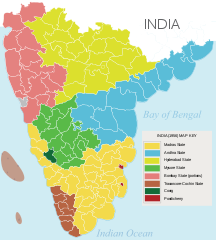
- 2008-01-07 02:35 AreJay 690×726×0 (615141 bytes) {{Information |Description= [[South India]]n states prior to the ''[[States Reorganisation Act]]'' (1956) |Source=self-made |Date= Jan 6, 2008 |Location= Atlanta, GA, USA |Author= [[User:AreJay|]] |Permission= GFDL, CC-Attrib |other_versions={{DerivativeVersions|South Indian territories 2009 de.svg}} }}
ᱨᱮᱫ ᱨᱮᱭᱟᱜ ᱱᱟᱜᱟᱢ
ᱚᱠᱛᱚ ᱨᱮ ᱞᱤᱱ ᱢᱮ/ᱚᱠᱛᱚ ᱨᱮ ᱨᱮᱫ ᱧᱮᱞ ᱞᱟᱹᱜᱤᱛ ᱞᱤᱱ ᱢᱮ
| ᱢᱟᱹᱦᱤᱛ/ᱚᱠᱛᱚ | ᱴᱤᱯ | ᱡᱚᱠᱷᱟ | ᱵᱮᱵᱷᱟᱨᱤᱭᱟᱹ | ᱠᱟᱛᱷᱟ | |
|---|---|---|---|---|---|
| ᱱᱤᱛᱚᱜ | ᱒᱓:᱓᱗, ᱒᱓ ᱱᱚᱵᱷᱮᱢᱵᱚᱨ ᱒᱐᱑᱔ | | ᱖᱗᱒ × ᱗᱔᱖ (᱓᱐᱖ KB) | Ras67 | black frame and Illustrator data removed |
| ᱐᱑:᱓᱕, ᱑᱓ ᱡᱩᱱ ᱒᱐᱐᱘ |  | ᱖᱙᱓ × ᱗᱔᱘ (᱗᱐᱘ KB) | File Upload Bot (Magnus Manske) | {{BotMoveToCommons|en.wikipedia}} {{Information |Description={{en|en:South Indian states prior to the ''en:States Reorganisation Act'' (1956)<br/> == Source data and maps == 1. Nizam's Territories: http://mahbubia.com/images/Map%20of%20Hyderab |
ᱯᱷᱟᱭᱤᱞ ᱵᱮᱣᱦᱟᱨ
ᱱᱚᱸᱰᱮ ᱫᱚ ᱟᱨ ᱮᱴᱟᱜ ᱥᱟᱦᱴᱟᱠᱚ ᱵᱟᱱᱩᱜ-ᱟ ᱡᱟᱸᱦᱟᱸ ᱥᱟᱶᱛᱮ ᱱᱤᱭᱟᱹ ᱨᱮᱫ ᱨᱮᱱᱟᱜ ᱡᱚᱱᱚᱲ ᱢᱮᱱᱟᱜ-ᱟ
ᱡᱮᱜᱮᱛ ᱡᱟᱠᱟᱛ ᱨᱮᱫ ᱵᱮᱵᱷᱟᱨᱟᱜ
ᱱᱚᱶᱟ ᱨᱮᱫᱠᱚ ᱵᱮᱵᱷᱟᱨᱟᱠᱟᱫ ᱣᱤᱠᱤᱠᱚ :
- ar.wikipedia.org ᱨᱮ ᱵᱮᱣᱦᱟᱨ
- bn.wikipedia.org ᱨᱮ ᱵᱮᱣᱦᱟᱨ
- ca.wikipedia.org ᱨᱮ ᱵᱮᱣᱦᱟᱨ
- en.wikipedia.org ᱨᱮ ᱵᱮᱣᱦᱟᱨ
- es.wikipedia.org ᱨᱮ ᱵᱮᱣᱦᱟᱨ
- eu.wikipedia.org ᱨᱮ ᱵᱮᱣᱦᱟᱨ
- fa.wikipedia.org ᱨᱮ ᱵᱮᱣᱦᱟᱨ
- fr.wikipedia.org ᱨᱮ ᱵᱮᱣᱦᱟᱨ
- he.wikipedia.org ᱨᱮ ᱵᱮᱣᱦᱟᱨ
- hi.wikipedia.org ᱨᱮ ᱵᱮᱣᱦᱟᱨ
- id.wikipedia.org ᱨᱮ ᱵᱮᱣᱦᱟᱨ
- kn.wikipedia.org ᱨᱮ ᱵᱮᱣᱦᱟᱨ
- ml.wikipedia.org ᱨᱮ ᱵᱮᱣᱦᱟᱨ
- mr.wikipedia.org ᱨᱮ ᱵᱮᱣᱦᱟᱨ
- ms.wikipedia.org ᱨᱮ ᱵᱮᱣᱦᱟᱨ
- ne.wikipedia.org ᱨᱮ ᱵᱮᱣᱦᱟᱨ
- ru.wikipedia.org ᱨᱮ ᱵᱮᱣᱦᱟᱨ
- ta.wikipedia.org ᱨᱮ ᱵᱮᱣᱦᱟᱨ
- te.wikipedia.org ᱨᱮ ᱵᱮᱣᱦᱟᱨ
ᱱᱚᱶᱟ ᱨᱮᱫ ᱨᱮᱱᱟᱜ ᱵᱟᱹᱲᱛᱤ ᱡᱮᱜᱮᱛ ᱵᱮᱵᱷᱟᱨ ᱧᱮᱞ ᱢᱮ ᱾