ᱯᱷᱳᱴ ᱣᱤᱞᱤᱭᱚᱢ, ᱥᱤᱧᱚᱛ
This article needs additional citations for verification. (August 2010) (Learn how and when to remove this template message) |
ᱯᱷᱳᱴ ᱣᱤᱞᱤᱭᱚᱢ ᱫᱚ ᱦᱟᱥᱴᱤᱝ, ᱠᱚᱞᱠᱟᱛᱟ ᱨᱮ ᱢᱮᱱᱟᱜ ᱢᱤᱫ ᱯᱷᱳᱴ ᱠᱟᱱᱟ ᱾ ᱱᱚᱶᱟ ᱫᱚ ᱵᱽᱨᱤᱴᱤᱥ ᱤᱱᱰᱤᱭᱟ ᱨᱮᱭᱟᱜ ᱵᱮᱝᱜᱚᱞ ᱯᱨᱮᱥᱤᱰᱮᱱᱥᱤ ᱚᱢᱚᱲ ᱨᱮ ᱵᱮᱱᱟᱣ ᱞᱮᱱᱟ ᱾ ᱜᱚᱝᱜᱟ ᱜᱟᱰᱟ ᱨᱮᱭᱟᱜ ᱥᱟᱠᱷᱟ ᱦᱩᱜᱽᱲᱤ ᱜᱟᱜᱟ ᱫᱷᱟᱨᱮ ᱨᱮ ᱠᱚ ᱵᱮᱱᱟᱣ ᱞᱮᱫ-ᱟ ᱾ ᱱᱚᱶᱟ ᱫᱚ ᱗᱐.᱙ ᱦᱮᱠᱴᱚᱨ ᱡᱟᱭᱜᱟ ᱨᱮ ᱵᱮᱱᱟᱣ ᱞᱮᱱ ᱛᱟᱦᱮᱸ ᱠᱟᱱᱟ ᱾
| ᱯᱷᱳᱴ ᱣᱤᱞᱤᱭᱚᱢ | |
|---|---|
| ᱠᱳᱞᱠᱟᱛᱟ, ᱥᱤᱧᱚᱛ | |
 ᱯᱷᱳᱴ ᱣᱤᱞᱤᱭᱚᱢ ᱵᱷᱤᱛᱨᱤ ᱯᱟᱦᱴᱟ ᱠᱷᱚᱱᱟᱜ ᱢᱤᱫ ᱪᱤᱛᱟ.ᱨ, ᱑᱘᱒᱘ ᱨᱮ | |
 ᱯᱷᱳᱴ ᱣᱤᱞᱤᱭᱚᱢ | |
| Coordinates | 22°33′28″N 88°20′17″E / 22.5577°N 88.3380°E |
| Type | Fortress, garrisoned and armoured Army Headquarters. |
| Site information | |
| Controlled by | ᱵᱽᱨᱤᱴᱤᱥ ᱤᱥᱴ ᱤᱱᱰᱤᱭᱟ ᱠᱩᱢᱯᱟ.ᱱᱤ ᱥᱤᱨᱟᱡᱽ ᱩᱫᱽ ᱫᱚᱣᱞᱟᱦ ᱤᱱᱰᱤᱭᱟᱱ ᱟᱨᱢᱤ (ᱱᱮᱛᱟᱨ) |
| Site history | |
| Built | ᱑᱖᱙᱖-᱑᱗᱐᱒ |
| In use | ᱑᱗᱘᱑ ᱠᱷᱚᱱ ᱱᱤᱛ ᱦᱟ.ᱵᱤᱡ |
| Battles/wars | ᱯᱞᱟᱥᱤᱭ ᱞᱟ.ᱲᱦᱟ.ᱭ |
| Garrison information | |
| Garrison | ᱮᱥᱴᱚᱨᱱ ᱠᱚᱢᱟᱸᱰ |
ᱱᱚᱶᱟ ᱯᱷᱳᱴ ᱫᱚ ᱤᱝᱞᱚᱸᱰ ᱨᱤᱱᱤᱡ ᱨᱟᱡᱽ ᱠᱤᱝ ᱣᱤᱞᱤᱭᱚᱢ III ᱛᱟᱭᱚᱢ ᱠᱚ ᱧᱩᱛᱩᱢ ᱟᱠᱟᱫᱟ ᱾[᱑] ᱯᱷᱳᱴ ᱥᱟᱢᱟᱝ ᱨᱮ ᱫᱚ ᱢᱚᱭᱫᱟᱱ ᱢᱮᱱᱟᱜ-ᱟ, ᱡᱟᱦᱟᱸ ᱫᱚ ᱠᱚᱞᱠᱟᱛᱟ ᱨᱮᱭᱟᱜ ᱢᱟᱨᱟᱝ ᱵᱟᱜᱟᱱ ᱠᱟᱱᱟ ᱾ ᱱᱚᱶᱟ ᱨᱮᱭᱟᱜ ᱵᱷᱤᱛᱨᱤ ᱜᱟᱨᱰ ᱚᱲᱟᱜ ᱫᱚ ᱵᱽᱞᱟᱠ ᱦᱳᱞ ᱚᱯᱷ ᱠᱚᱞᱠᱟᱛᱟ ᱞᱮᱠᱟᱛᱮ ᱵᱮᱵᱷᱟᱨᱟᱜ ᱠᱟᱱᱟ ᱾
ᱵᱮᱱᱟᱣ ᱰᱷᱚᱝ
ᱥᱟᱯᱲᱟᱣThe Fort is built of brick and mortar in the shape of an irregular octagon with an area 5 km². Five of its sides face landward, and three towards the Hooghly River. The design is that of a star fort, suited to defence against cannon firing solid shot, and dates from before the advent of explosive shells. A dry moat 9 m deep and 15 m broad surrounds the fort. The moat can be flooded but is designed as an area in which to use enfilade (or "flanking") fire against any attackers reaching the walls. There are six gates: Chowringhee, Plassey, Calcutta, Water Gate, St Georges and the Treasury Gate. There are similar forts at places like Thalassery in Kerala.[᱒]ᱪᱷᱟᱸᱪ:Full citation needed
ᱱᱟᱜᱟᱢ
ᱥᱟᱯᱲᱟᱣ

There are two Fort Williams. The original fort was built in the year 1696 by the British East India Company under the orders of Sir John Goldsborough which took a decade to complete. The permission was granted by Mughal Emperor Aurangzeb.[᱓][᱔] Sir Charles Eyre started construction near the bank of the Hooghly River with the South-East Bastion and the adjacent walls. It was named after King William III in 1700. John Beard, Eyre's successor, added the North-East Bastion in 1701, and in 1702 started the construction of the Government House (Factory, see Factory (trading post)) at the centre of the fort. Construction ended in 1706. The original building had two stories and projecting wings. In 1756, the Nawab of Bengal, Siraj Ud Daulah, attacked the Fort, temporarily conquered the city, and changed its name to Alinagar. This led the British to build a new fort in the Maidan.
ᱜᱮᱞᱮᱨᱤ
ᱥᱟᱯᱲᱟᱣ-
 Fort William 1735
 -
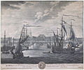
![Fort William, Calcutta, 1756[᱕]](//upload.wikimedia.org/wikipedia/commons/thumb/7/70/Fort_William%2C_Calcutta.jpg/120px-Fort_William%2C_Calcutta.jpg) Fort William, Calcutta, 1756[᱕]
Fort William, Calcutta, 1756[᱕] -
 Fort William 1760
 -
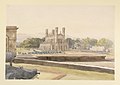
![First English Chapel, Fort William, Calcutta. Raised in 1714, with contribution of Rs. 1000 by the East India Company (p. 197, March 1824)[᱖]](//upload.wikimedia.org/wikipedia/commons/thumb/9/93/First_English_Chapel%2C_Fort_William%2C_Calcutta._Raised_in_1714%2C_with_contribution_of_Rs._1000_by_the_East_India_Company_%28p._197%2C_March_1824%29.jpg/120px-First_English_Chapel%2C_Fort_William%2C_Calcutta._Raised_in_1714%2C_with_contribution_of_Rs._1000_by_the_East_India_Company_%28p._197%2C_March_1824%29.jpg) First English Chapel, Fort William, Calcutta. Raised in 1714, with contribution of Rs. 1000 by the East India Company (p. 197, March 1824)[᱖]
First English Chapel, Fort William, Calcutta. Raised in 1714, with contribution of Rs. 1000 by the East India Company (p. 197, March 1824)[᱖] -
 St Peter's Church, Fort William by William Prinsep 1835
 -
 The interior of the Arsenal, Fort William by William Prinsep 1835
 -
 Main entrance, Fort William 2013
 -
 South gate, Fort William 2013
 -
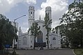 St. Peter's Church, Fort William, Kolkata
 -
 Semaphore Tower, Fort William, Kolkata

![Fort William, Calcutta, 1756[᱕]](/wiki/%E1%B1%A8%E1%B1%AE%E1%B1%AB:Fort_William,_Calcutta.jpg)

![First English Chapel, Fort William, Calcutta. Raised in 1714, with contribution of Rs. 1000 by the East India Company (p. 197, March 1824)[᱖]](/wiki/%E1%B1%A8%E1%B1%AE%E1%B1%AB:First_English_Chapel,_Fort_William,_Calcutta._Raised_in_1714,_with_contribution_of_Rs._1000_by_the_East_India_Company_(p._197,_March_1824).jpg)


ᱥᱟ.ᱠᱷᱭᱟ.ᱛ
ᱥᱟᱯᱲᱟᱣ| ᱣᱤᱠᱤᱢᱤᱰᱤᱭᱟ ᱠᱚᱢᱚᱱᱥ ᱨᱮ Fort William (Kolkata) ᱵᱟᱵᱚᱛᱫᱽ ᱛᱮ ᱨᱮᱫ ᱢᱮᱱᱟᱜᱼᱟ ᱾. |
- ↑ Krishna Dutta (2003). Calcutta: A Cultural and Literary History. p. 71. ISBN 9781902669595.
- ↑ Nandakumar Koroth, History of Forts in North Malabar
- ↑ Sudip Bhattacharya, Unseen Enemy: The English, Disease, and Medicine in Colonial Bengal, 1617 – 1847, Cambridge Scholars Publishing, 30 Jun 2014, p.54
- ↑ "Fort William Kolkata India - History of Fort William". www.makemytrip.com. Archived from the original on 10 ᱮᱯᱨᱤᱞ 2019. Retrieved 27 ᱰᱤᱥᱮᱢᱵᱚᱨ 2018.
- ↑ Grant, James (1873). British Battles On Land and Sea. Vol. Volume II. Cassell & Company, Limited. p. 69.
{{cite book}}:|volume=has extra text (help) - ↑ "The Gentleman's Magazine, and Historical Chronicle". The Gentleman's Magazine, and Historical Chronicle. 94 (1): 197. ᱯᱷᱮᱵᱽᱨᱩᱣᱟᱨᱤ 1824. Retrieved 13 ᱰᱤᱥᱮᱢᱵᱚᱨ 2017.
Coordinates: 22°33′27.57″N 88°20′16.99″E / 22.5576583°N 88.3380528°E